Levenshulme Market Last Day This Year

Sadly today is the last trading day for Levenshulme Market in 2023. The Market is taking a break after celebrating 10 years of trading and intends to return in 2024.

The Market has been clear that there are a variety of reasons for this unexpected pause but the main one appears to be Manchester City Council deciding to impose a new fee in addition to the site licence fee the Market already pays. A full explanation from Levenshulme Market is available HERE (June 7) with a further update HERE (July 13).

Levenshulme Community Association would like to thank everyone involved in Levenshulme Market and for making the Market such a big part of Levenshulme as well as such a success winning several awards and supporting traders, with several going on to open businesses in Levenshulme. We hope that Levenshulme Market and Manchester City Council can find a solution and that the Council fully recognises the value of the Market and the contribution it has made to Levenshulme as a Community Interest Company and social enterprise, and the value it adds to our community.

Even though the weather might be showery today go down and give Levenshulme Market a big send off at the last Market of this year. We hope to see Levenshulme Market back again as soon as possible.

Selective Licensing In Levenshulme

Manchester City Council has launched a consultation on proposals for Selective Licensing in parts of Levenshulme. This would affect private rented properties.

This is the area proposed in Levenshulme. It would Include flats, suffixed and sub-addresses in this area.

StreetPost code
1-48 Damien Street (All)M12 4GW
72-118 Hemmons Road (Evens)M12 4QG 
M12 5ST
37-94 Longden Road (All)M12 5SG
1-38 Maida Street (All)M12 4QQ
1-57 Ollier Avenue (Odds)M12 5SU
1-42 Seddon Street (All)M12 4GP
81-135 Stovell Avenue (Odds)M12 5SE
M12 4GN

Levenshulme | Proposed areas for Selective Licensing | Manchester City Council

The consultation will run for 10 weeks from 5th October – 14th December 2022.

Please see link below to Manchester City Council’s website, which provides background information about the proposals and includes details of how residents and landlords can have their say, by completing an online questionnaire or by attending an in person drop-in event.

www.manchester.gov.uk/consultations

Further information from Manchester City Council is available HERE and below:

Why are we considering selective licensing?

We have introduced a revised Private Rented Sector Strategy (2020-2025) with a detailed implementation plan. This sets out the Council’s approach to the private rented sector over the next five years. The new Housing Strategy (2022-2032) reaffirms our commitment to improving the safety, quality and management of private rented sector homes.

There are approximately 90,000 private rented properties which is 38% of the total housing for the City of Manchester. We know that many PRS (Private Rented Sector) properties provide good quality accommodation, however there are areas of Manchester where PRS properties are not managed to a good standard.

We work with teams across Community Safety, Compliance and Enforcement regularly and work with landlords in the private rented sector in dealing with complaints about anti-social behaviour, poor property management, waste issues and proactively work to remove any concerns in these areas. 

Despite this, we have not seen sustained improvements in areas unless additional interventions are introduced. Enforcement against individual properties alone will not improve standards to the level required across each area. 

Manchester has previously had an accreditation scheme, and we have considered voluntary accreditation as part of our work in Manchester. However, our experience is that these schemes inevitably attract landlords who are already providing a good service to their tenants and do little to engage or improve the property conditions of those landlords who are not. 

The Council has the power to introduce ‘selective licensing schemes’ in areas of Manchester. In these areas private landlords, or their managing agents, would need to have a licence for each house that they rent out. There are approximately 3,200 private rented properties in the current selective licensing schemes and the proposed selective licensing schemes would affect 1,100 private rented properties.

Selective licensing ensures that:

  • The proposed licence holder is fit and proper to manage their properties. 
  • The licence holder complies with the conditions of the licence, leading to improvements in property management and reductions in anti-social behaviour 
  • Property inspections can be targeted 
  • Landlords provide necessary certification
  • Unlicensed landlords can face an unlimited fine if prosecuted through the courts, or up to £30,000 if issued by the council. 

To make sure that selective licensing helps to improve social or economic conditions, we want to introduce designated zones within the ward areas of Cheetham, Levenshulme, Longsight, Moss Side and Whalley Range, and Rusholme. 

See which areas we are proposing for selective licensing and have your say

Find out more about the benefits of selective licensing and how areas are chosen

Read conditions the licence holder must comply with

How an area is picked for selective licensing

When a Selective Licensing designation is being considered an area has to be experiencing one or more of the following conditions: 

  • Low housing demand  
  • A significant and persistent problem caused by anti-social behaviour 
  • High levels of migration
  • Poor property conditions
  • High level of deprivation 
  • High levels of crime

Before identifying any areas for selective licensing a ‘hotspot’ mapping exercise was undertaken looking at levels of anti-social behaviour, crime and service requests relating to housing and environmental issues, as well as levels of deprivation across the City. This data was overlaid to identify areas where challenges were likely to be concentrated.  

Updated statistics for each of the areas can be found on our key statistics page.

View the key statistics for: 

Views were then sought from local Neighbourhood and enforcement teams on boundaries for potential selective licensing areas within these ‘hotspot’ areas based on their local knowledge of the issues within each area.

In September 2020 the Council Executive held a meeting on past selective licensing in order to inform any new selective licensing schemes.  The new licensing schemes being considered are in relation to tackling property condition, deprivation and anti-social behaviour.  For more details on this you can read point 96 in the report and associated appendix on this topic in the Wednesday, 9 September, 2020, 2pm (manchester.gov.uk) agenda for Council Executive.

In June 2022 the Economy Scrutiny Committee reviewed updated local statistics which confirmed that the proposed areas continue to meet the necessary criteria for selective licensing and approved an outline consultation plan. For more details you can read section 11 onwards in the report and associated appendix in the Thursday, 23rd June, 2022 2.00pm (manchester.gov.uk) agenda for Economy Scrutiny

How much would a licence cost?

The proposed licence fee is £800. The licensing fee is split into two parts, the application fee and the grant fee which is payable before any licence is issued. Non-payment of the grant fee will result in an application being delayed.

Once we have set an area for selective licensing, landlords will have three months to get their licences.

See the current fee structures

Income generated from licensing fees will be used to pay for the consultation process, administration, management and running of the scheme.

The Council does not generate surplus funds from selective licensing schemes. The income generated, the bulk of which is collected in years one and two, is required to manage and resource the scheme for its full designation.

Who Owns The City Public Land Map

A new map has been developed to improve transparency around public land ownership and use and to encourage public debate around how this resource can be better used to address social and environmental needs.

The map will allow you to identify land that is owned by Manchester City Council. It will also allow you to explore the privatisation of Council-owned land in the central wards of Cheetham, Miles Platting & Newton Heath, Ancoats & Beswick, Ardwick, Hulme, Deansgate and Piccadilly.

The map is the result of research carried out by Dr Tom Gillespie (University of Manchester) and Dr Jonathan Silver (University of Sheffield) with Greater Manchester Housing Action investigating the privatisation of public land in Manchester. The project is supported by the University of Manchester and ESRC. More information is available here.

To view the map go to whoownsthecity.org

Call for Active Neighbourhood Consultation to be extended

Levenshulme Community Association and Levenshulme Traders Association have jointly called for the current Active Neighbourhood consultation to be extended. There are multiple problems with the way the consultation is being run. We believe these problems must be corrected and then the consultation should be extended to allow proper community engagement.

The letter and concerns are reproduced below and have been sent on 11 January 2022 to: Levenshulme councillors (Zahid Hussain, Dzidra Noor and Basat Sheikh); Burnage councillors (Azra Ali, Ben Clay and Bev Craig who is also Manchester City Council Leader); Manchester City Council Executive member Tracey Rawlins; Andy Burnham (Greater Manchester Mayor); and local MPs Afzal Khan and Jeff Smith. Copied to the Levenshulme and Burnage Active Neighbourhood Project Team.

Continue reading

Active Neighbourhood Consultation and Full Plans

  • Information released 17 December 2021
  • Updated with Grangethorpe Drive plan 14 January 2022
  • NEW DEADLINE for consultation 30 January 2022 (announced 14 January)

Manchester City Council has released the final plans for the Levenshulme and Burnage Active Neighbourhood today. A consultation is now open for the next six weeks.

The overview map is below. An interactive version that you can zoom in on is available HERE.

Scroll down to see ALL information published by the the council.

How can you comment on these proposals?

View the map and have your say

There will also be two engagement events held on:
  • 13 January 6.30pm to 7.30pm
  • 20 January 6.30pm to 7.30pm

If you would like to attend one of these events please email the council’s Project Team at levyburnageproject@manchester.gov.uk to register your interest. You will be sent details on how to join.

Continue reading

Expanded Levenshulme Market Secures Another Four Years

CORRECTION:

Unfortunately it appears this report was a little premature. The information is contained in a report to the council’s planning committee and was not the actual decision of the planning committee. Apologies for this mistake. It turns out what was reported was a planning officer’s report with a recommendation to approve the planning application. The decision was due yesterday (18/02/21) but has now been deferred to a future date to allow additional information to be submitted. We hope whatever clarifications required are secured. The current arrangements remain in place until August 2021.

————-

(Post edited to reflect the current situation pending a final decision by the council planning committee.)

The popular and successful Levenshulme Market operating as a Community Interest Company is here to stay [has submitted an application to continue] for another four years.

Manchester City Council approved [considered] the planning application today (18 February 2021) for an operating licence for Levenshulme Market for another four years. Not just as it is, though, as the market has big ambitions and will be operating throughout the year. These operating times were approved:

  • Fridays (up to 12 weeks a year) 16.00-22.00
  • Saturdays (52 weeks a year) 10.00-16.00
  • Sundays (up to 12 weeks a year) 10.00-17.00

The previous operating times for the market were:

  • Saturdays (March to December), 10.00-16.00
  • Fridays (ups to 10 days per year), 17.00-21.00

The market will [has applied to] continue to operate over the same area it currently uses across the southern half of the Levenshulme Station car park taking up approximately 50% of available parking spaces and providing 50 market stalls. The provision for 10 market stalls previously permitted on Levenshulme Village Green has been [would be] removed [under the new arrangements].

There are also plans to install a mains electricity supply for use by the market that will enable the current use of a generator to be phased out.

The decision [recommendation] includes this assessment:

“The operation market would give the district a distinctive retail offer that would contribute to the continued regeneration of the district centre, which would be particularly important to local economic recovery in the post-COVID period. The market is operated as a local social enterprise and many of its traders are from the surrounding area thereby demonstrating its links with the local area. It would also provide an important outlet for the sustained operation of local businesses. The development would present continued opportunities for social interaction and engagement across a diverse community.”

A new site management plan is to be agreed formalising the existing arrangements that also includes provision of stewards to direct vehicles and pedestrians, new signs and arranging remote parking for traders who do not require access to their vehicles so that the remaining parking spaces are fully accessible to the public when the market is operating.

Levenshulme Market Plan 2021

New Lidl Store Consultation Closes Today

Lidl are proposing to build a new supermarket on the Fallowfield Retail Park on Birchdfields Road near the roundabouts at the top of Kingsway.

The plans would mean demolishing all buildings on the right hand side of the entrance road apart from the Hawthorne Medical Practice and replacing them with a new Lidl store which is anticipated to create around 40 jobs.

You can read the MEN article about the plans HERE. Please note the phone number given at the end of this article is incorrect.

You can comment on the proposals HERE.

The consultation ends on Friday 15 January 2021.

Fallowfield Retail Park Lidl Store Plans, (image courtesy of Lidl GB)

Active Neighbourhood Trials Announced

Active Neighbourhood will start very soon

The formal notification of the Levenshulme and Burnage Active Neighbourhood has been published. You can view the announcement HERE or read the text below. The notice was dated 18 December 2020 and states it will come into force on 26 December 2020.

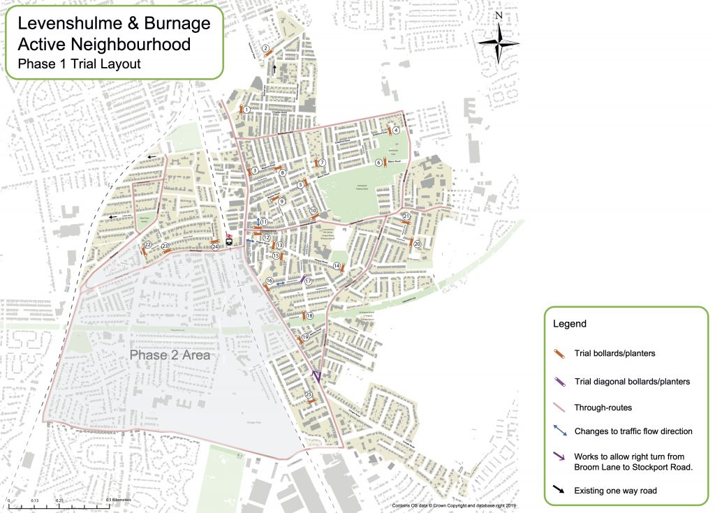
Phase 1 of the scheme will install 14 road blocks / “modal filters” for at least six months across Levenshulme. The council has said that a further five road blocks / “modal filters” might be added during the trial but this has not been confirmed yet.

The council had originally said the trial measures would be installed from 4-8 January 2021 but now says “early January”.

A consultation on measures for Phase 2 (covering parts of Burnage Ward) is still live. You can take part and submit comments HERE or by emailing the council directly <levyburnageproject@manchester.gov.uk>. This consultation closes on 21 January 2021.

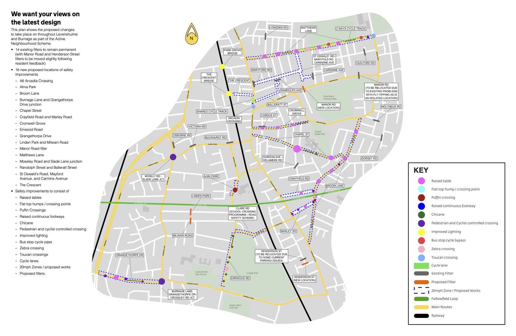
Where are the road blocks / “modal filters” going?

The 14 filters which will be installed on a trial basis early in the New Year are at:

  • Buckhurst Road
  • Cardus Street (North)
  • Delamere Road and Gordon Avenue
  • Dorset Road
  • Caremine Avenue
  • Guildford Road
  • Henderson Street
  • Longden Road
  • Manor Road (East)
  • Mayford Road
  • Molyneux Road
  • Osborne Road
  • Portville Road and Randolph Street
  • Victoria Road

Unfortunately the council has not provided any detailed plans of where these road blocks / “modal filters” will be located or whether parking spaces will need to be removed to allow vehicles accessing these roads to turn around despite repeated requests for greater clarity and detail.

Five more proposed filters are being paused until an assessment can be made of what their impact would be on surrounding residential streets, but could still form part of the phase 1 trial, with alternative solutions to be considered as part of the wider scheme development.  These are at Chapel Street (East), Crayfield Road, Dunstable Street, Manor Road (West) and Marley Road.

Public Announcement Text

Road Traffic Regulation Act 1984

Notice is hereby given that on the 11th December 2020 Manchester City Council made the following Orders under Sections 9 and 10 of the Road Traffic Regulation Act 1984. The Orders, which will be introduced on an experimental basis for a period of up to 18 months are as follows:- City of Manchester (Various Roads, Levenshulme) (Prohibition of Driving Except Cycles And Revocation) (Experimental) Order 2020

The effect of the Order will be to introduce the following:

Experimental Prohibition Of Driving (Except Cycles) on –

Buckhurst Rd – both sides from its junction with Albert Road in a northerly direction for a distance of 3 metres.

Cardus St – both sides from its junction with Cromwell Grove in a northerly direction for a distance of 3 metres.

Caremine Ave – both sides from a point 10 metres west of its junction with Lonsdale Road in a westerly direction for a distance of 3 metres.

Dorset Rd – both sides from its junction with Fairbourne Road in a westerly direction for a distance of 3 metres.

Gordon Ave – Gordon Avenue/Delamere Road junction, from the north east corner of the junction to the south west corner with a minimum width of 2 metres.

Guildford Rd – both sides from a point 2 metres south west of its junction with Norley Drive in a south westerly direction for a distance of 3 metres.

Henderson St – both sides from a point 32 metres north west of its junction with Nall Street in a north westerly direction for a distance of 3 metres.

Longden Rd – both sides from its junction with Stovell Avenue in an easterly direction for a distance of 2 metres.

Manor Rd – both sides from a point 80 metres east of its junction Audley Road in an easterly direction for a distance of 3 metres.

Mayford Rd – both sides from a its junction with Stockport Road in an easterly direction for a distance of 3 metres.

Molyneux Rd – both sides from its junction with Cumbrae Road in a southerly direction for a distance of 2 metres.

Osborne Rd – both sides from its junction with Slade Lane in a north easterly direction for a distance of 5 metres.

Randolph St – both sides from a point 13.5 metres south of its junction with Mayford Road in a southerly direction for a distance of 3 metres.

Victoria Rd – both sides from its junction with Albert Road in a north westerly direction for a distance of 3 metres.

City of Manchester (Cardus Street, Manchester) (Experimental Revocation of One Way Traffic) Order 2020 The above Order is revoked in its entirety.

The Orders shall come into operation on 26th December 2020.

A copy of the Orders, together with the plans showing the roads to which they relate and a Statement of the Council’s Reasons for making the Orders may be inspected at Customer Service Centre Ground Floor, Town Hall Extension M60 2LA (for Sat. Nav. use M2 5DB) between the hours of 9.00am and 4.30pm on Monday to Friday inclusive for a period of 6 months until 26th June 2021. Due to Covid 19 restrictions please ensure that the Contact Centre is open before attending. If it is closed or you are unable to attend, a copy of the plan may be requested (without payment) by emailing phlegal@manchester.gov.uk or writing to the address at the end of this notice.

The City Council will be considering in due course whether the provisions of the Order should be continued in force indefinitely. Within a period of six months from the coming into force of the Order or if the Order is subsequently varied or amended from the coming into force of the variation or modification (whichever is the latter) any person may object to the indefinite continuation of the provisions of the Orders.

Any person wishing to object should submit their grounds of objection in writing to phlegal@manchester.gov.uk or the address below no later than 26th June 2021 quoting reference L/GS/EVD2001/1887.

Any person who wishes to question the validity of the Orders or of any provision contained in it on the grounds that they are not within the powers conferred by the Road Traffic Regulation Act 1984 or on the grounds that any requirement of that Act or of any instrument made under it have not been complied with in relation to the Order may within six weeks from 11th December 2020 apply to the High Court for such purpose.

Signed: Fiona Ledden, City Solicitor PO Box 532, Town Hall, Manchester, M60 2LA

Dated: 18th December 2020

TM REF: 226043115-01

Active Neighbourhood Delays

It looks like the start of the Levenshulme and Burnage Active Neighbourhood trial has been delayed (although it is possible we have missed the formal announcement).

The council would have had to issue formal notification of the Phase 1 road blocks / “modal filters” trial today at the latest if it was to start on 19 December as previously announced. However, there is no notice in the “public notices” section of the MEN. The council’s website also makes no mention of the trial starting on 19 December and the project website also has no announcements or updates.

In fact, reference to the Phase 1 trial start date has been removed from the council’s website which now says “The trial measures will start to be put in place from December (during school holidays).” So the trial is still planned to start in December but it doesn’t look like that will happen on 19 December.

The phrasing on the council’s website also suggests all elements of the trial will not be installed at the same time. This might have something to do with the proposed road works at the end of Broom Lane and Chapel Street where those roads meet the A6 that are part of the plans released in September 2020. These haven’t even started yet. Without those changes all residents and businesses in the blocked off area off Chapel Street would have to access their properties via Elbow Street. If the trial measures are installed in phases that would also suggest the trial will run for longer than the original six months as all measures must be trialled for a minimum of six months.

So we have more waiting with a continued lack of information. It isn’t even clear today – the legal deadline for announcing the Experimental Traffic Regulation Order to commence on 19 December – when the council might even start to install the trial measures, how long the trial measures will take to install fully, where specifically there are to be located on the roads, how turning points and access will be facilitated, whether emergency services have approved any plans yet or even what will be included in the plans as they might change from the revised plans announced in September. Or they might not.

Phase 2 (Burnage)

At the moment we also do not know how and plans for Phase 2 covering Burnage Ward will be decided on or trialled. There is an ongoing consultation on Phase 2 until 21 December 2020.

We understand an online consultation event was planned for Crossley Road and Grangethorpe Drive although no details were provided when requested.

Monitoring and data gathering

Additional traffic and air quality equipment is also planned for some of the busier “through routes” but this might not be installed until next year. We will provide further updates once any changes or additions are confirmed. This monitoring is being done by Manchester Urban Observatory at the University of Manchester and started earlier this summer. Unfortunately this means there may not be any substantive pre-trial data for comparison with the trial data once the road blocks / “modal filters” are installed for our busiest roads.

The Active Neighbourhood project itself has not installed any traffic or air quality monitoring equipment in the almost two years the project has been running despite previous claims this was being done in the summer of 2019. Information on the Manchester Urban Observatory monitoring was previously reported by the LCA HERE and the data is freely available on the MUO website HERE.

Further consultation

The Active Neighbourhood project has confirmed its intention to hold further consultation events online with businesses and what it identifies as “the BAME community”. This was announced at the online events at the end of October 2020. So far not dates have been confirmed for these events but we will provide information as and when they are confirmed. The second stage consultation on the revised plans announced in September ended on 4 November 2020.

The further delays and lack of information is, to say the least, disappointing.

Clarification on road works near schools

For clarification please note that the roadworks being undertaken on Barlow Road at the back of Chapel Street Primary School, the previous work done on Broom Lane to install traffic calming and the work done around Alma Park Primary School has nothing to do with the Levenshulme and Burnage Active Neighbourhood project. This work is part of a separate initiative for safer streets around schools. A previous LCA article about this is available HERE.

Active Neighbourhood Update: Documents, Deadlines & Feedback

The LCA has requested all publicity material for the Levenshulme and Burnage Active Neighbourhood Project including in different languages. All material that is currently available can be downloaded below as PDF documents. There are instructions here on how to comment on the plans online, by email and by written questionnaire including deadlines that have now changed.

Be aware that all the maps in the printed materials are different and the deadline for comment has been extended by a week because of a mistake in the printed materials that have been distributed.

As of today (16 October 2020) only the questionnaire leaflet is available in any language apart from English. That language is Romanian.

UPDATE: Urdu version of the questionnaire leaflet added on 23 October 2020

UPDATE: Bengali version of the questionnaire leaflet added on 22 October 2020

UPDATE: Arabic version of questionnaire leaflet added on 19 October 2020.

Continue reading

New Active Neighbourhood Plans released

The revised plans for the Levenshulme and Burnage Active Neighbourhood have been released. Full information is available on the new website HERE.

The project has now been split into two with Phase 1 covering Levenshulme and Phase 2 covering Burnage. A trial of road blocks / “modal filters” will start in December 2020 and last for a minimum of six months.

Note that a “modal filter” is the name given to something that blocks the road to vehicular traffic but still allows access through for pedestrians and cyclists (and presumably mopeds and motorbikes).

Manchester City Council says:

We now have a plan for the future direction of the project, and have decided to tackle it in two phases. We would like your feedback on some of the measures which we are going to trial (Phase 1). The trial measures will start to be put in place from December (during school holidays).This is also a great way for the scheme to be seen in action, tested and analysed, so it can be tweaked or changed where required but also allow peoples habits to change and through traffic to re-route.

Because of the density of schools in the Cringle Park (Phase 2) area, and issues with traffic congestion, we are continuing to seek opinions from local residents, businesses and schools on what measures are needed and where before they are trialled.

We hope to commence the trial in the Festive season break in December and will last a minimum of 6 months. The final designs for the Active neighbourhood will be drawn up based on the results of the consultation and implemented within 18 months should the funding application be successful.

MCC Active Neighbourhood Plans

The Phase 1 trial area excludes Burnage. No date has been suggested yet for Phase 2 in Burnage. The Phase 1 / Phase 2 split has been done based on political Wards, not the Park Area cells the Project has identified which is why the Henderson Street road block / “modal filter” is included in Phase 1.

The Levenshulme Phase 1 trial identifies 25 road blocks / “modal filters” outlined on the map below. The revised plans are not very different to the original plans. We will look at them in detail and post further information once we have worked out what differences there are.

The Phase 1 trial is still primarily for road blocks / “modal filters”. The council is also asking for feedback on where temporary crossings and traffic calming could be located as part of its Phase 1 consultation. The council says:

The trial includes a number of temporary crossing points and traffic calming measures to provide immediate benefits on routes that have been raised through previous consultation. [ * ]

We understand from previous feedback that traffic volume and speeds make certain streets hard to cross. We’d like you to tell us where you feel crossing points or traffic calming may help day to day life and make getting around safer and easier.

Further community feedback on the locations of these is welcomed, so that a final Trial Plan can be developed. The trial plan has a degree of flexibility once live, but we need to allow the trial to bed in to understand how habits change and the trial is being used. 

MCC Active Neighbourhood crossings and traffic calming

[ * NOTE: there is no evidence of this on the map for the Phase 1 trial]

Give your feedback

Phase 1 feedback (Levenshulme) can only be made by responding to the 25 locations identified by the council. You can, however, drop a pin on the map for the Phase 2 feedback (Burnage) to identify a location and comment where you think an intervention could or should be located.

Phase 1 (Levenshulme)

You can comment HERE on the proposed road blocks / “modal filters”.

You can comment HERE on where you think crossings and traffic calming should go.

You can comment HERE on the whole scheme.

Phase 2 (Burnage)

You can comment HERE on what measures you think should be included in Phase 2.

How has the Project Changed?

There are a number of differences between the May proposals and the new proposals released in September. A summary is provided here for reference.

Levenshulme and Burnage Active Neighbourhood Project v1 and v2 Comparison

( RB/MF = Road Block / “Modal Filter” )

 Version 1May 2020Version 2 Sept 2020v2 Map ref.Changes
Green Bank Park Area    
Longden RoadRB/MFRB/MF1Same as v1
Armitage AvenueRB/MFRB/MF2Same as v1
Mayford RoadRB/MFRB/MF3Same as v1
Guildford Road / Audley RoadRB/MF (Diagonal)RB/MF4Moved along Guildford Road and now a standard RB/MF
Stovell Avenue / Northmoor RoadBus Gate  Bus Gate removed
Manor Road 1 (between Barlow Road and Rushmere Avenue)RB/MFRB/MF5Same as v1
Manor Road 2 RB/MF6Moved to where a new crossing was proposed originally
Caremine Avenue RB/MF7EXTRA RB/MF
Portville RoadRB/MFRB/MF8Same as v1
Dunstable StreetRB/MFRB/MF9Same as v1
Barlow RoadRB/MFRB/MF10Same as v1
Cardus Street (North) RB/MF11EXTRA RB/MF and road changed to two-way traffic
Chapel Street Park Area    
Cardus Street (South) RB/MF12Same as v1
Chapel Street (West)RB/MFRB/MF13Same as v1
Chapel Street (East)RB/MFRB/MF14Same as v1
Chapel Street / Stockport Road junction   Changed to two-way traffic
Atlas PlaceRB/MFRB/MF15Same as v1
Delamere Road (West)RB/MFRB/MF16Same as v1 with road changed from one-way to two-way traffic
Delamere Road / Gordon AvenueRB/MF (Diagonal)RB/MF17Same as v1
Crayfield RoadRB/MFRB/MF18Same as v1
Marley RoadRB/MFRB/MF19Same as v1
Dorset RoadRB/MFRB/MF20Same as v1
Molyneux RoadRB/MFRB/MF21Same as v1
Broom Lane / Stockport Road junction   Changed to allow left and right turning
Cromwell Grove / Stockport Road junction   Changed to allow left and right turning
West Point Gardens Area    
Osborne RoadRB/MFRB/MF22Same as v1
Victoria RoadRB/MF (Diagonal)RB/MF23Changed from diagonal RB/MF to standard and moved to junction with Albert Road
Buckhurst RoadRB/MFRB/MF24Same as v1
Green DriveRB/MF  RB/MF removed (private road)
Lytham RoadRB/MF  RB/MF removed and road left as it is now
Cringle Park Area (Burnage)    
Fortuna Grove / Monica GroveRB/MF (Diagonal)  Further consultation
Burnage Hall RoadRB/MF  Further consultation
Slade Lane (near Linden Park)Bus Gate  Further consultation
Errwood Road (near Alma Park Primary)Bus Gate  Further consultation
Clare RoadRB/MF  Further consultation
Alma RoadRB/MF  Further consultation
Henderson StreetRB/MFRB/MF25Same as v1
L&B Active Neighbourhood Version Comparison (May plan v1 / September Plan v2)

Levenshulme & Burnage Active Neighbourhood Phase 1 Map

You can view the map online HERE or download a PDF version below.

“Our Future Manchester” Council Survey

Manchester City Council is half way through its ten year strategy for the city. It is now doing a survey about priorities at the half way point. You can go direct to the survey (deadline 23rd September 2020) HERE.

The questions in the survey are weighted towards prioritising issues that have already been determined but there is also opportunity to comment.

The Council’s description / introduction to the survey is below for reference or can be viewed HERE.

The current version of the “Manchester Strategy” is available HERE. The existing priorities state that the city needs to be:

  • Thriving — creating great jobs and healthy businesses that our people benefit from. 
  • Filled with talent – homegrown in all our local communities as well as the world’s best. 
  • Fair — with equal chances for all to unlock their potential, no matter where in our city they were born, or where they live. 
  • A great place to live — with loads to do, leading the way to a low-carbon future that creates new opportunities for our residents
  • Buzzing with connections — world-class transport and brilliant broadband that put all Mancunians in touch with chances to get ahead. 

The Council says:

“The challenge to now include everyone in this successful future is bigger than ever. But Manchester is determined to do it. We’ve seen, through the COVID spring of 2020, what coming together in new ways, and doing things differently, can achieve.

Help to reset Manchester’s ambition to be the place where everyone can be everything they want to be. Take the survey, tell us your priorities, share your ideas and let us know how you can play your part in moving Our Manchester on.”

Manchester City Council Strategy Survey
Continue reading

School Crossing Safety Improvements

Significant improvements are taking place to the roads around our schools as part of a road safety project by Manchester City Council. Full details of the improvements are provided below.

The schools affected in this area are:

  • Acacias Primary School
  • Alma Park Primary School
  • Chapel Street Primary School
  • Crowcroft Park Primary School
  • Levenshulme High School for Girls
  • St Mary’s Primary School
  • St Richard’s Primary School

The aims are:

  • to reduce the speed that traffic can move around the school
  • to increase the visibility of the crossing
  • to stop drivers parking on or near the crossing.  

Manchester City Council says:

“We’re committed to making the roads around our schools much safer. These improvements are essential and should encourage more families to walk to school.

The improvements have been designed specifically for each crossing location, taking into account facts and figures relating to accident data and evidence from the site and surrounding areas.

We believe that these measures will make our school neighbourhoods much safer environments, and reduce the likelihood of accidents happening.”

Manchester City Council School Road Safety Projects

The council announcements are available HERE. Work has already started on the Chapel Street Primary School improvements.

If you wish to comment on these changes you can email the council at: engcp8@manchester.gov.uk

Please note that this project is not part of the Active Neighbourhood proposals currently in development that were previously badged as Levenshulme Bee Network.

What are the changes?

Acacias Primary School

  • Burnage Lane / School Entrance
    • Zebra Crossing
    • Bollards
    • Guardrail
  • Crossley Road and Moorton Avenue
    • Speed cushions / traffic calming
    • Bollards

Alma Park Primary School and St Mary’s Primary School

  • Errwood Road / Clare Road / Buckhurst Road
  • (assumed roads as specific locations not specified apart from Buckhurst Road)
    • Flat top junction/crossing
    • Tactile paving
    • New signage
    • Renew road markings
    • Tighten Buckhurst Road junction
    • Raised puffin crossing
    • Speed cushions
    • Bollards and railings

Chapel Street Primary School

  • Barlow Road / Cromwell Grove
    • Tighten junction
    • Realign island
    • Signalised crossing
    • ‘No Waiting At Any Time’ markings
  • Broom Lane / Chapel Street
    • Speed cushions
    • New signs and road markings

Crowcroft Park Primary School / St Richard’s Primary School

  • Northmoor Road / Stovell Avenue / Wilpshire Avenue
  • (assumed roads as specific locations not specified)
    • Kerb buildout to slow traffic
    • Bollards to prevent dangerous parking
    • Dropped kerbs for increased access
    • Tactile paving
    • Refreshed road markings
    • Reduced foliage for increased visibility

Levenshulme High School for Girls

  • Burnage Lane / school gates
    • Zebra crossing
    • Bollards
    • Guardrails
  • Crossley Road/ Moorton Ave
    • Speed cushions/ traffic calming
    • Bollards

Levenshulme Bee Network Through Routes

A trial will start in July 2020 of some of the Levenshulme Bee Network changes to our roads. 29 locations will have changes with roads being blocked to vehicle traffic. But which roads will not be affected?

Residents have made their own maps to help people see which routes will not have road blocks to vehicles on them starting in July (referred to as “modal filters”). These roads are likely to have significantly increased traffic.

The reason these have been done is the Levenshulme Bee Network maps do not show which roads traffic in the area will be redirected onto and can be used as “through routes”. They have been done by residents to help everyone understand the impact of the project and so people can plan how to change the routes they take from July.

Roads that traffic will be diverted onto:

  • Albert Road
  • Barlow Road
  • Broom Lane 
  • Cromwell Grove 
  • Crossley Road
  • Grangethorpe Drive 
  • Hemmons Road
  • Kingsway 
  • Matthews Lane 
  • Moseley Road
  • Mount Road
  • Slade Lane (north of Albert Road)

See below for the maps. Further information on the July changes can be found HERE

Continue reading

Videochats About Road Changes

Levenshulme Bee Network is holding a series of “webinars” on the “Filtered Neighbourhood Trials” starting in July 2020. These involve blocking off roads to motorised vehicles in 29 locations across the area. Pedestrians and cyclists can still access these roads through the “filters”.

Please see the LCA post HERE for full details including maps.

The Webinars will be held:

Saturday 4th July

  • 11.00-12.30 Chapel Street Park Area
  • 13.00-14.30 Cringle Park Area

Sunday 5th July

  • 11.00-12.30 Greenbank Park Area
  • 13.00-14.30 West Point Gardens Area

To participate in a webinar send and email to hello@levenshulmebeenetwork.co.uk quoting the Park Area you are interested in.

UPDATE

You can now register directly using the links below. After registering, you will receive a confirmation email containing information about joining the webinar.

Topic: Chapel Street Park Area Webinar + Q&A

  • When: Jul 4, 2020 11:00 AM
  • Register in advance for this webinar: HERE

Topic: Cringle Park Area Webinar + Q&A

  • When: Jul 4, 2020 01:00 PM
  • Register in advance for this webinar HERE

Topic: Greenbank Park Area Webinar + Q&A

  • When: Jul 5, 2020 11:00 AM
  • Register in advance for this webinar HERE

Topic: West Point Gardens Park Area Webinar + Q&A

  • When: Jul 5, 2020 01:00 PM
  • Register in advance for this webinar HERE

ANOTHER UPDATE

Q & A

If you would like to send in any questions for the Q and A – we are using the links below to collect questions so people can ask and then upvote the most popular ones to be answered in the sessions.

Submit Cringle Field Park Webinar questions HERE

Submit Chapel Street Park Webinar questions HERE 

Submit Greenbank Park Webinar questions HERE

Submit West Point Gardens Webinar questions HERE

If you would like to get in touch about anything please email trial@levenshulmebeenetwork.co.uk

Dramatic Road Changes From July 2020

Levenshulme and surrounding areas are about to experience major changes to our roads.

This is the first stage of the changes being imposed by the Levenshulme Bee Network Project. This is a new idea to create a “Filtered Neighbourhood” and to make walking and cycling easier by blocking off roads and restricting access for motorised vehicles. A whole host of other ideas are planned as well. This is just the start.

Travelling around Levenshulme and getting to and from the area will never be the same again.

12 June update

Please note that the information below was correct when it was posted. However, Levenshulme Bee Network has now changed the description on its website about the July 2020 changes. There is nothing on their website to indicate this has been changed.

Original text when the announcement was made:

“In the next few weeks we will be installing 29 temporary modal filters throughout the neighbourhood.

These will remain in place for a minimum of six months whilst we consult and tweak the filters with your feedback. They will then become permanent within 18 months.”

New text as of 12 June 2020:

“In the next few weeks we will be installing 29 temporary modal filters throughout the neighbourhood.

The trial will be undertaken using an experimental traffic regulation order which means that we can make changes following your feedback and monitor the impact for the first 6 months before the Council decides if the filters will be implemented on a permanent basis. All feedback from residents and monitoring of traffic, pedestrian and cycling levels as well as air quality levels will be considered before any of the filters are installed permanently.”

See below for details of the roads that will be affected, what will be done in July and maps including these changes.

Continue reading

Levenshulme Community Manifesto Meeting

Come along and find out about the new Levenshulme Community Manifesto on Wednesday 28th February at The Klondyke. Developed by and for our community it is a statement of what our community wants for the future of Levenshulme.

What Is Your Vision For Levenshulme?

Everyone is welcome to a meeting to discuss the future of Levenshulme at 7.30pm on Wednesday 27th September at The Klondyke (1Burnage Range).

This will be the first of a series on public meetings and consultations where we can all suggest ideas and priorities for how we want Levenshulme to develop over the next few years.

There is no set agenda as this is something driven by us all but discussion will be guided and notes kept so all views are valued. This is an initiative by our community for our community.

  • How do you want to see Levenshulme develop?
  • What are your priorities for the future?
  • What are the main issues that need addressing?
  • How can we work together effectively to make our community what we want it to be?
  • What is your vision for Levenshulme?

A6 Resurfacing 22 April – 7 May

MANCHESTER CITY COUNCILTEMPORARY ROAD TRAFFIC REGULATION ORDER

ROAD TRAFFIC REGULATION ACT 1984 SECTION 14 (AS AMENDED)

ORDER NO. MCC0001742-
The City of Manchester (STOCKPORT ROAD, LEVENSHULME) (TEMPORARY Prohibition of Vehicular Traffic) Order 2017

The effects of the notice will be to prohibit access and egress by vehicular traffic at the side roads connecting onto Stockport Road between Broom Lane and Crossley Road as specified in the schedule to this Notice. Between 07:00 hrs and 19 00hrs Weekends only.

The City Council is satisfied that this prohibition is necessary in order to facilitate Highway Improvement Scheme works. It is expected that the works will be in progress between 22 April 2017 and 07 May 2017 Stockport Road will remain open at all times for the duration of the works.

SCHEDULE

Crossley Road 

Lloyd Road 

Hardicker Street  

Nall Street  

Cringle Road

Broom Lane

One Manchester Presentation On Chapel Street Development 

Judy Noah, Head of Development at One Manchester will be at the Levenshulme Community Assoiciation AGM this afternoon to provide information and answer questions on the Chapel Street housing development.

The meeting starts at 14.30, Saturday 11th March, in the Community Studio in the Arcadia Library and Leisure Centre.

Everyone is welcome.

Major Levenshulme Housing Development Approved

A major housing development has been approved for the former Atlas Engineering site off Chapel Street.

The development will provide:

  • Erection of 64 no. dwellings comprising of:
  • 28 x two bedroom apartments with associated 28 space car park and communal bin storage area;
  • 22 x three bedroom houses;
  • 6 x four bedroom houses;
  • 8 x four bedroom houses with garages;
  • boundary treatments (including walls, railings gates and fences), formation of new access road linking Elbow Street and Stanhope Street and landscaping following demolition of existing buildings.

This will be a significant improvement as this site has been derelict land for many years. Developers Mulbury will start work in Spring 2017.

David Wroe, head of Mulbury Living, said:

“This site provides an excellent opportunity to increase the supply of high-quality, sustainable family homes in Levenshulme. By regenerating a site that has fallen into disrepair, these homes will also have a significant positive impact on the local area, including a new street layout and landscaping.

The development has been designed with respect for the existing homes in the area. They will be of a modern appearance with the use of red-facing brick and rendered gables, while the apartment block will acknowledge the architecture of the former Atlas Mill.”

View the planning application HERE

View the article from Place North West HERE

News article from Mulbury HERE

See the plan superimposed on an aerial photograph HERE (Thanks to Tim Blackwell)


Levenshulme Neighbourhood Planning Forum Meeting

Levenshulme Neighbourhood Planning Forum Meeting
Thursday 22nd September

19.30 @ Inspire, Stockport Road
Open, public meeting, everyone welcome.

  • Find out why our application to the council has been delayed for so long.
  • Hear about our meeting with Sir Richard Leese, Manchester City Council Leader.
  • Raise any issues you have on themes for the group to address in Levenshulme.

Agenda

  1. Update from the forum and designation application
  2. Area of designation vs ward boundaries
  3. Next scrutiny committee meeting Tuesday 11th October at 14.00
  4. Current discussion issues
  5. Party
  6. Next annual general meeting will be in December

LCA Community Forum Wednesday 27th July

The next LCA Community Forum will be held at the Klondykeon Wednesday 27th July. Doors open at 7:15. Meeting starts at 7:30.

The agenda will include:

  • An update on the Levenshulme Neighbourhood Planning Forum
  • News on a new Linked Up Levenshulme Project 
  • Discussion of ideas for crime prevention and safety

There will also be time for anyone to raise concerns of their own about life in Levenshulme.

The LCA Community Forum is an initiative of Levenshulme Community Association. These are open public meetings for everyone in Levenshulme – residents, businesses, landlords, community groups or anyone else – to find out what is going on and raise questions about our area.

Information and ideas are shared with the council and our local councillors to work in partnership for a better Levenshulme.

Stockport Road Resurfacing

The resurfacing of Stockport Road will start on Saturday 13th August. This will take place in three stages as outlined in the letter from Manchester City Council below.

This will be a major improvement to Levenshulme. Thanks to all councillors and council officers involved in securing the funding to enable this work to be completed.

———–

FROM: Manchester City Council

Date: 20.07.16

Road Resurfacing on Stockport Road, A6

 Dear Sir / Madam,  

I am writing to inform you of resurfacing works to Stockport Road.

Due to securing additional funding for Local Highway Maintenance Manchester City Council will be undertaking significant road resurfacing works on key routes into the City.

Large sections of Stockport Road are to be resurfaced with initial works being carried out between Broom Lane and Matthews Lane.

As a resident or business in the area you will no doubt be aware of how busy Stockport Road is throughout the day. To avoid causing severe delays our works are planned to be done during off peak periods including weekends and nights.

The works have been planned in three sections to minimise disruption.

Section 1 is from Broom Lane to Elbow Street, including the junction of Alma Road. This work is due to commence on Saturday 13th August 2016 and it is intended to progress as follows;

Saturday 13th August 08:30 to 19:30 removal of existing surface. This will be done using traffic signals maintaining a single lane of traffic past the works.    

Sunday 14th August 09:30 to 19:30 replacing first layer of surfacing. Stockport Road will be completely closed between Broom Lane to Elbow St. Local diversions will be signed.

Monday to Friday 15th to 19th August 21:00 to 05:00 (nights) Replacing the final surface and new road markings. Stockport Road will be completely closed between Broom Lane to Elbow Street.

Section 2 is from Elbow Street to Barlow Road. This work is due to commence on Saturday 20th August 2016 and it is intended to progress as follows;

Saturday 20th August 08:30 to 19:30 removal of existing surface. This will done using traffic signals maintaining a single lane of traffic past the works

Sunday 21st August 09:30 to 19:30 replacing first layer of surfacing. Stockport Road will be completely closed between Elbow Street and Barlow Road. Local diversions will be signed.

Monday to Friday 22nd to 26th August 21:00 to 05:00 (nights) Replacing the final surface and new road markings. Stockport Road will be completely closed between Elbow Street and Barlow Road. 

Section 3 is from Barlow Road to Matthews Lane. This work is due to commence on Saturday 27thth August 2016 and it is intended to progress as follows;

Saturday 27th August 08:30 to 19:30 removal of existing surface. This will done using traffic signals maintaining a single lane of traffic past the works

Sunday 28th August 09:30 to 19:30 replacing first layer of surfacing. Stockport Road will be completely closed between Barlow Road and Matthews Lane. Local diversions will be signed.

Monday to Friday 29th to 31st August 21:00 to 05:00 (nights) Replacing the final surface and new road markings. Stockport Road will be completely closed between Barlow Road and Matthews Lane.

Works may be suspended on the Bank Holiday 29th August depending on progress made.

 Diversions will be locally managed with signage.

The dates given are approximate, weather and other factors can delay us but if we make good progress we may well finish early.

The noisiest operation is the removal of the existing road surface and removal of manholes and service boxes. We have planned our operations so that this work will be undertaken on Saturdays from 08:30 to 19:30. Noisy works at night have been minimised as far as possible but there may still be some disturbance. The removal of the existing surface and the laying of the new materials progress at a steady walking pace and although several passes of the machinery is required it is unlikely you will be disturbed for prolonged periods.

Pedestrian access will be maintained to all properties during working hours. However there will be no access for vehicles in the working areas during working hours. Vehicular access to areas adjoining streets and the sections of Stockport Rd outside of the working area will be maintained by Traffic Marshalls.

Please ensure all vehicles are removed from the working areas during the times and dates listed above. Any vehicles obstructing the works will be removed from site by Manchester City Council.

J. Hopkins (Surfacing) Ltd will be carrying out the works on behalf of Manchester City Council.

If you are experiencing any undue problems, please contact the Site Supervisor Tel No. 0771 0712 708 during the working shift.

I apologise for any inconvenience that you may encounter and seek your cooperation.

Should you require any further information, please email the planned maintenance team at Manchester City Council plannedmaintenance@manchester.gov.uk or call on 0161 234 1970

Yours faithfully,

Paul Swann.

———–

Council Consultation On Takeaways

Manchester City Council are consulting on new powers to control Hot Food Takeaways. 

The consultation is available HERE

All comments must be received by the Council by 5pm on 20th September 2016

The announcement from the council follows:

“Manchester City Council Draft Hot Food Takeaway Supplementary Planning Document 

The Council would like to inform you that it is beginning a consultation on the draft Hot Food Takeaway Supplementary Planning Document and would welcome any comments you may have on this issue.   

The draft Hot Food Takeaway SPD builds on existing policies in the Core Strategy relating to health and the night time economy, including policies SP1, C1, C2, C10 and DM1. The intention of the SPD is to provide further detail on these policies in relation to hot food takeaways. A copy of the Core Strategy can be found on the City Council’s website http://www.manchester.gov.uk/downloads/download/4964/core_strategy_development_plan.   

The SPD is accompanied by a Consultation Statement and a Strategic Environmental Assessment (SEA) Screening. The Consultation Statement provides details related to the previous consultation in the Summer 2015 and how this stage informed the preparation of the draft document. The SEA Screening confirms that there is no need to complete a full SEA. 

The draft hot food takeaway SPD is the next stage following the Issues and Evidence gathering stage, which was completed last Summer. This stage seeks comments on the draft document and there are a number of ways to do this: 

 Through our consultation portal –

http://consult.manchester.gov.uk/portal/planning/supplementary_planning_documents/reports/hot_food_takeaway_spd/draft_hot_food_takeaway_supplementary_planning_document

By email to planningstrategy@manchester.gov.uk 

By Post to Planning Strategy Team 

                City Policy 

                Manchester City Council 

                Level 5, Town Hall Extension 

                PO Box 532 

                Manchester 

                M60 2LA 

All comments must be received by the Council by 5pm on 20th September 2016. 

Following the consultation the Council will consider all the comments and possibly make modifications before adopting the final version of the SPD, at which point it will inform the Council’s decision making process.   

If you require any further information on this consultation please do not hesitate to contact Rebecca Friday on 0161 234 4561.”

Friends Of Levenshulme Station Access Petition

Friends of Levenshulme Station (FoLS) have organised a petition for better access at Levenshulme station.

The summary is below and you can go to the petition HERE

Levenshulme Train Station Needs Accessibility For All

The Disability Discrimination Act 1995 and the Equality Act 2010 makes it illegal to discriminate against users in respect of disabled access to transport, such as buses and trains.

Currently Levenshulme train station does not meet these requirements at all. Access onto the station and station platforms is not possible for anyone who is disabled or has limited mobility, parents with young children in prams and passengers with bikes.

Friends of Levenshulme Station have made numerous attempts to communicate with Network Rail and Northern Rail to understand the timescale for accessibility improvements to Levenshulme station. We have been assured that it is indeed a priority station, but are no clearer as to what that means for access improvements.

The only offered solution at present is calling Northern Rail customer service 24 hour in advance for a taxi to be booked and paid for, but even this is only offered to passengers with a registered mobility disability.

This is not reasonable and is not in line with 21st century public transport travelling aspirations. The growing population of Levenshulme deserve more!

Let’s persuade Network and Northern Rail to make our train station ACCESSIBLE FOR ALL. Let’s encourage them into the 21st century!

Thanks for helping the Friends of Levenshulme Station. Spread the word!

Levenshulme and Gorton South Election Hustings 2016

Once again Levenshulme Community Association is organising hustings for the local elections. All candidates have been invited. Everyone is welcome. These are open, public meetings and an opportunity for anyone to ask questions of any candidates in the May local elections.

Levenshulme Ward

Wednesday 27th April

19.30 start

Klondyke

1 Burnage Range, Levenshulme, M19 2HQ

Gorton South Ward

Thursday 28th April

Inspire

747 Stockport Road, Levenshulme, M19 3AR

Transport Card On Hold After Failure by TfGM And Atos

A single transport card for Manchester is on hold following a complete failure of the Atos company to deliver the system for Transport for Greater Manchester (TfGM).

The scheme – similar to the Oyster Card system in London – is being rethought after it became clear Atos was completely incapable of delivering the system. The MEN reports that according to TfGM all costs incurred (£15m) have been refunded by Atos and TfGM will now explore how to get the failed project moving again.

There does not appear to be any comment from Tony Lloyd, Greater Manchester Mayor, who is responsible for transport across Greater Manchester.

Read the MEN report HERE

What’s Your Vision For Levenshulme?

Levenshulme Neighbourhood Planning Forum would love to hear your ideas for how you want Levenshulme to develop. What’s your vision for our community?

14.00 today in the Community Studio at Arcadia Library and Leisure Centre.

This isn’t just bout dull planning matters, this is bout what we want our community to be and to look like.

Everybody welcome.


Levenshulme Neighbourhood Planning Forum Meeting 

The Levenshulme Neighbourhood Planning Forum will be holding a meeting on Saturday 19th March 2016 at 14.00 in the Community Studio in the Arcadia Library and Leisure Centre.

Come along and say how you want Levenshulme to develop.


Help Shape Levenshulme’s Future

There is a general meeting of the Levenshulme Neighbourhood Planning Forum this Thursday 3rd December at the Inspire Centre, 19.00-21.00.
We’ve now had three events to gather new ideas and thoughts for Levenshulme and there are 7 areas of interest. We will need to start developing groups that will start focussing on these items:

  1. Parking and Traffic management (traffic lights, one way system, cycling, parking, pedestrian crossing)
  2. Public and green spaces (protection, support to improve green spaces, playground equipment, community facilities)
  3. Build environment (mix of housing, land use, describing the look of our area, conservation area, list of significant buildings)
  4. Environmental improvements (improving existing housing stock, bulk buying, energy and insulation)
  5. Environmental health and wast management (rubbish and litter, fly tipping, recycling, vermin, bins)
  6. Communication (community engagements)
  7. Business and economic development ( A6 development, business diversity.

If you are interested in one of these areas and you would like to look in developing ideas in relation to the above items, please let us know. We will be discussing these areas at our meeting on Thursday and will start putting together groups that will investigate these areas further.

I know we are a little late in releasing the agenda for this Thursdays meeting, but we’ve been quite busy in the background. 
Agenda:

  1. Update our planning application for forum status.
  2. Discuss the above described work groups
  3. Current planning issues, and the method in which the forum deals with current planning application.
  4. Any other business

There are not many items on the agenda, but I think the discussions around the workgroups will be taking most of the meeting.

I hope you will be able to attend and see you on Thursday.

Maria van Elk
Chair, Levenshulme Neighbourhood Planning Forum

www.levenshulmenpf.org.uk


Planning Forum Public Events

Levenshulme Neighbourhood Planning Forum (LNPF) public events.
Come along and find out about the LNPF and how our community can influence local planning issues.
What matters to you? Green spaces? Affordable housing? Improving our High Street? Supporting businesses for local jobs? Protecting buildings? Takeaways? Parking? Litter? Transport?
Everyone is welcome to get involved and help decide what the priorities and desires are for people who live and work in Levenshulme. This will become our plan for our community.
Saturday 31st October

09.30-16.30

Levenshulme Library (Cromwell Grove)
Thursday 5th November

15.00-19.00

Inspire Centre (Stockport Road)
Saturday 7th November

10.00-16.00

Levenshulme Market (Station Car Park)


Council Consultation On Hot Food Takeaways

Manchester City Council is consulting on planning guidance for hot food takeaways. This would be come part of the council’s Strategic Plan as a Supplementary Planning Document (SPD).

The consultation is available HERE
If you wish to comment you must register with the council’s consultation portal. You can do this by following the instruction on the link above.

The council’s introduction is provided below:

The City Council intend to prepare a Hot Food Takeaway Supplementary Planning Document and would welcome any comments you have on this issue.

The Manchester Core Strategy includes a number of policies relevant to Hot Food Takeaways and the intention of the SPD is to provide further detail on these policies. A copy of the Core Strategy can be found on the City Council’s website HERE

We are particularly interested in how you think planning policy relating to hot food takeaways can support the most appropriate mix of uses within our District and Local Centres and promote healthy lifestyles, especially for young people.

We would like your views about the right planning policy for Hot Food Takeaways.

Petition To Control Speeding On Manor Road

A petition has been set up by Levenshulme resident Sue Millichap to stop the excessive and dangerous speeding on Manor Road.

The petition text says:

“Manor Road is a residential street in Levenshulme, Manchester. The road runs alongside Greenbank Playing Fields – a large open park where children and families play. Manor Road is very long, wide and straight and it connects two main roads together. As such, drivers use it as a ‘rat run’ and incessant speeding has led to a large number of pet fatalities and near misses with children. Some residents have tried to take action by gesturing to drivers to slow down in order to protect our children and pets but have been faced with abuse and threats. We need speed calming measures that actually work. We want speed bumps that span the full width of the road. We have to act now before a child is killed. Enough is enough. 

We are aware that there are many roads in Levenshulme that are suffering this issue but residents from all areas of Levenshulme use Greenbank Park.”
You can view and sign the petition HERE


Shell Garage Licence Application

It has been drawn to our attention that the Shell Garage at 1081 Stockport Road (close to the junction with Crossley road and McVities) has applied for a 24 hour license to sell alcohol and that some people may wish tocomment.

Details of the application are available HERE

You can comment by sending an email to Manchester City Council at:

premises.licensing@manchester.gov.uk

The deadline for comments is 3rd September.