
- Information released 17 December 2021
- Updated with Grangethorpe Drive plan 14 January 2022
- NEW DEADLINE for consultation 30 January 2022 (announced 14 January)
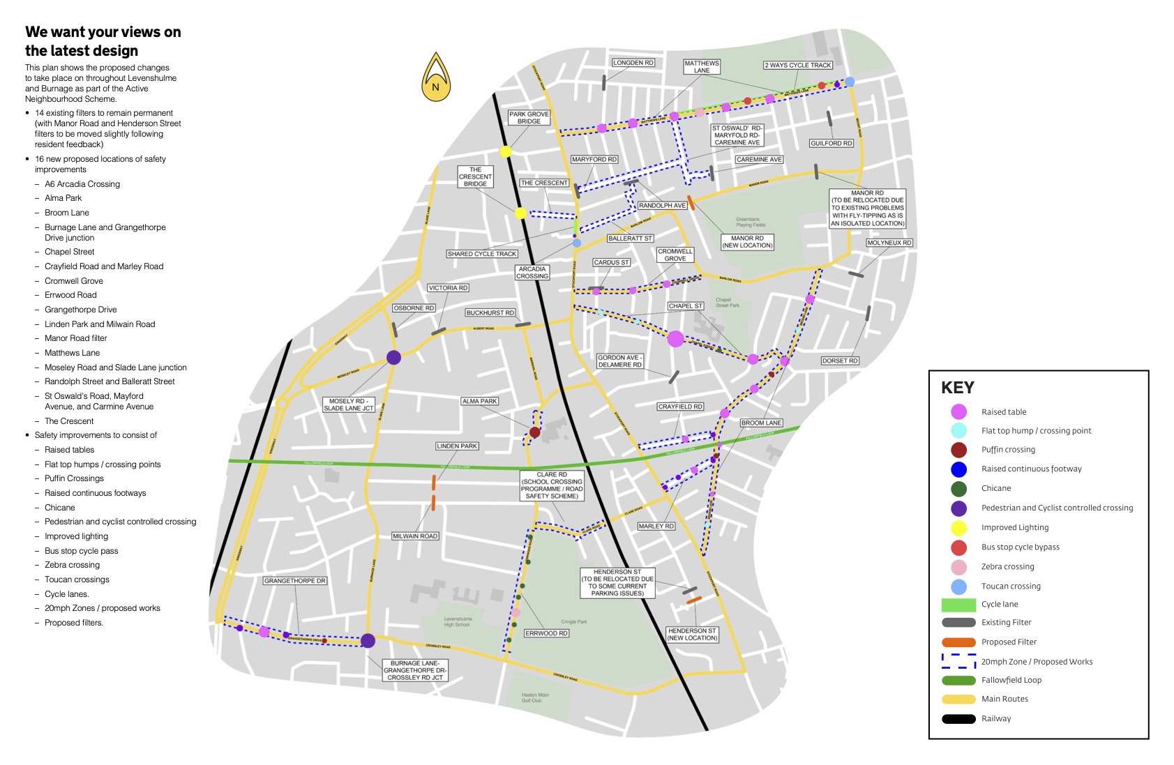
Manchester City Council has released the final plans for the Levenshulme and Burnage Active Neighbourhood today. A consultation is now open for the next six weeks.
The overview map is below. An interactive version that you can zoom in on is available HERE.
Scroll down to see ALL information published by the the council.
How can you comment on these proposals?
View the map and have your sayThere will also be two engagement events held on:
- 13 January 6.30pm to 7.30pm
- 20 January 6.30pm to 7.30pm
If you would like to attend one of these events please email the council’s Project Team at levyburnageproject@manchester.gov.uk to register your interest. You will be sent details on how to join.
The Next Phase
This is the latest stage of the consultation and approval process which has taken more than three years and involved engagement with thousands of people; one of our most extensive Highways consultations ever.
This is one scheme for the whole Levenshulme and Burnage area, which was previously divided into phases to allow a trial to be completed and work to be able to progress. The fourteen filters trialled in the previous phase are now proposed to be permanent, and as a result of feedback during the trial, two of the permanent filters in Henderson Street and Manor Road East will be moved slightly.
The current consultation completes this process, and gives details of the rest of the proposed scheme. In the last consultation, people told us where they felt the issues were which prevented them walking and cycling in the area. Local monitoring also gathered vital data, for example showing that cars speeding at more than 60mph were recorded in the area – a clear example of behavioursActive Travel Neighbourhoods are trying to mitigate.
We listened to your feedback, and made a case for how the issues could be addressed through traffic calming measures. As a result we have designed a scheme larger than originally planned, and allowed us to address issues in the main areas which residents identified.
Find out more about the types of features being used
Read about the proposed changes by area
The measures being proposed
The traffic-calming measures most people are familiar with are speed humps and cameras. This project uses different methods that have been proved to be effective in other places.
The measures include:
- Bollards – Putting bollards at junctions allows pedestrians and cyclists to move through them freely, and allows access to a street while discouraging motorists from cutting through (rat-running), or from parking on pavements.
- Speed tables and road narrowing – At some junctions we will narrow the road to make crossing easier, and add a raised table. This measure is seen as one of the most effective traffic-calming measures. It can be used as an informal crossing for pedestrians, and could be combined with road narrowing. Speed tables are more acceptable than speed humps for buses, and the size and location of the tables can vary – from a straight road, to spanning a four-arm junction.
- Chicanes – In some places, roads will be narrowed away from a junction to reduce the road to one carriageway. This normally involves extending the kerb, and using bollards. Motorists need to drive more carefully in narrowed sections of road, which results in slower vehicle speeds. Narrowing targets a specific part of the road, can be used on junctions, can prevent vehicle parking, and makes it easier for pedestrians to cross.
- New crossings and improved junctions – These help those on bike or foot to cross busy roads separately, avoid right turns in front of traffic for cyclists and can be used to allow cyclists to set off from lights before cars.
Find out more about where changes are being proposed
Areas and measures being proposed
Along with the information from residents in previous consultations, we have looked at informationabout accidents involving pedestrians, cyclists and motorists in this area, along with driver behaviour. We’ve also looked at the places where people are likely to want to travel to from home, e.g. schools and colleges, leisure centres and libraries, churches, shops, and food and drink outlets.
View the map and have your say
MATTHEWS LANE

Proposed measures include:
- 20mph zone signs and road markings on red surface for traffic coming from A6 London Road onto Matthews Lane
- Remove radius kerbs and pave across the end of alleyways to prevent trip hazard.
- A raised table and controlled crossing points at the junction of Matthews Lane with Stovell Avenue and Agnes Street
- Flat top humps to make crossing easier at the junctions of Deepcar Street, Maida Street, Cuthbert Street, Hemmons Road, Lonsdale Road and Leybourne Avenue.
- A raised table and controlled crossing points at the junction of Seddon Street and Brook Street with Matthews Lane
- A raised table and controlled crossing points at the junction of Prestage Street and St Oswald Street.
- A signed quiet cycling route via St Oswald Street and Mayford Road.
- A parallel crossing (made up of a pedestrian zebra crossing and a cycle crossing next to each other) on Matthews Lane between the junction with Newdale Road and the junction with Lonsdale Road.
- A signed quiet cycling route via Newage Road and Hemmons Road.
- An improved entrance to the cycling route through the park.
- A segregated cycle lane and 0.5m kerbed buffer zone on both sides of Matthews Lane form the junction with Prestage Street and St Oswald Street to the junction with Lonsdale Road (south side), then becoming a 2-way cycle lane on the north side of Matthews Lane from near the junction with Lonsdale Road to the junction with Mount Road.
- Kerb build outs to protect cycle lanes.
- A signed quiet cycling route via Lonsdale Road to Manor Road filtered area.
- A raised table and controlled crossing points at the junction of Hornbeam Road with Matthews Lane.
- A raised platform and cycle bypass at bus stops on Matthews Lane, to allow cycle to pass behind the bus stop.
- A raised table and controlled crossing points at the junction of Audley Road with Matthews Lane.
- A raised table and controlled crossing points at the junction of Granmere Avenue with Matthews Lane.
- At the junction with Mount Road:
- Remove existing Toucan crossing north of junction on Mount Road.
- Create a new signal junction with Toucan controlled crossings (which allow pedestrians and cyclists to cross separately) on all the arms of the junction.
- Add 20MPH zone signs and road markings on red road surfacing.
A6 ARCADIA CROSSING

Proposed measures include:
- New Toucan crossing outside the library (which allows pedestrians and cyclists to crossb separately)
- Footway built out on the junctions of Stockport Road with Yew Tree Road and Barlow Road, to narrow carriageway width at the approach to the new crossing.
- Tactile paving to be installed on the crossing point at Barlow Road.
- Existing central island and tree to be removed
- Additional tree pits and planting where space allows
- Extra bollards to protect pedestrian and shared footway and prevent vehicles parking on footway
- Signed quiet cycle route along Yew Tree Avenue Park Grove Bridge
THE CRESCENT
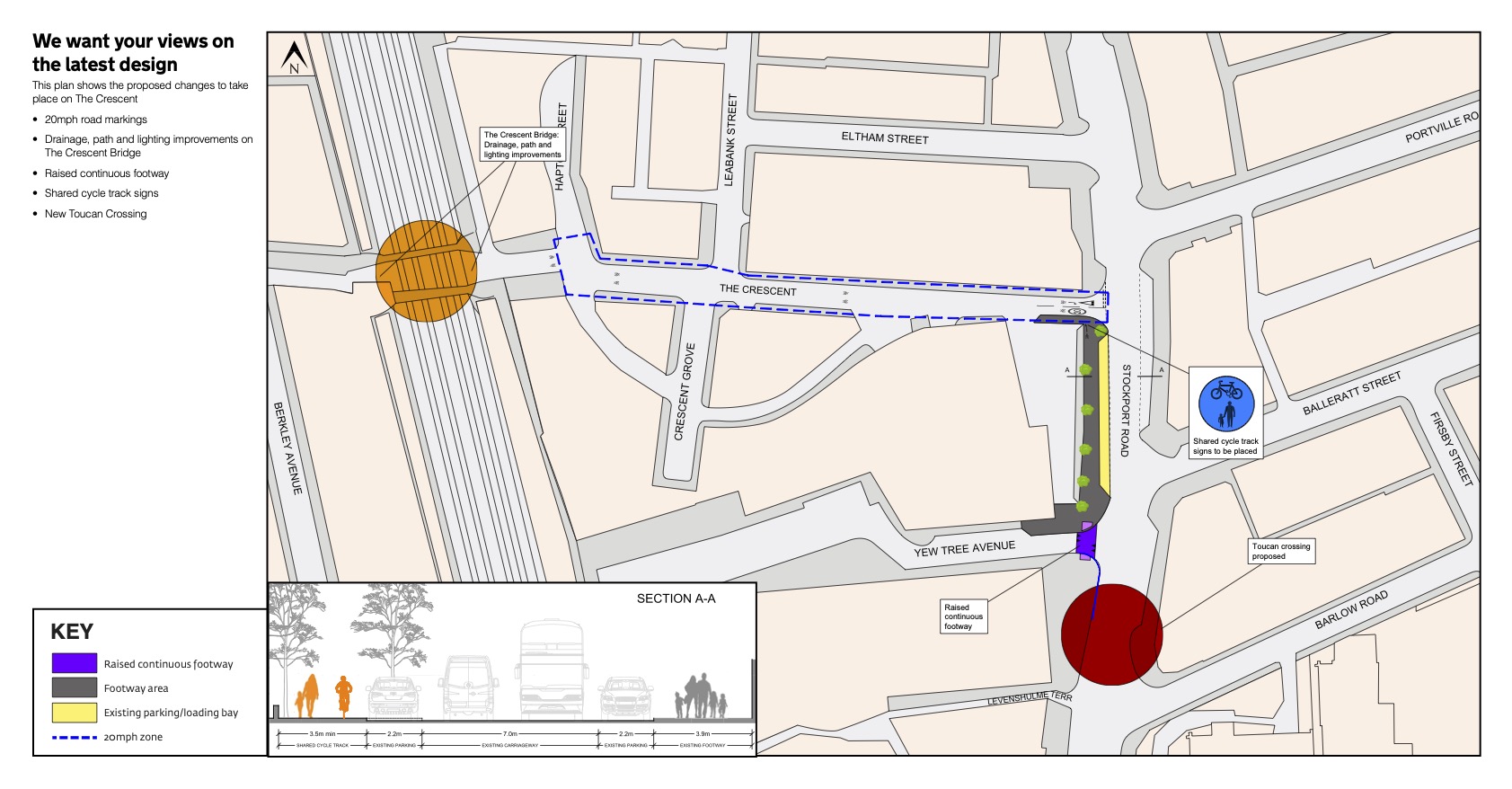
Proposed measures include:
- Drainage, path and lighting improvements at the Crescent Bridge
- Creating a 20MPH zone along The Crescent
- Signs indicating shared pedestrian walkway and cycle track to be place on Stockport Road, between the Crescent and Yew Tree Avenue.
- Installing a raised, continuous footway at the crossing point on Yew Tree Avenue where it meets Stockport Road.
- Installing a controlled ‘Toucan’ crossing (which allows pedestrians and cyclists to cross separately) on Stockport Road near the junction with Barlow Road (where the current pedestrian refuges are).
ST OSWALD ROAD, MARYFOLD ROAD, CAREMINE AVENUE
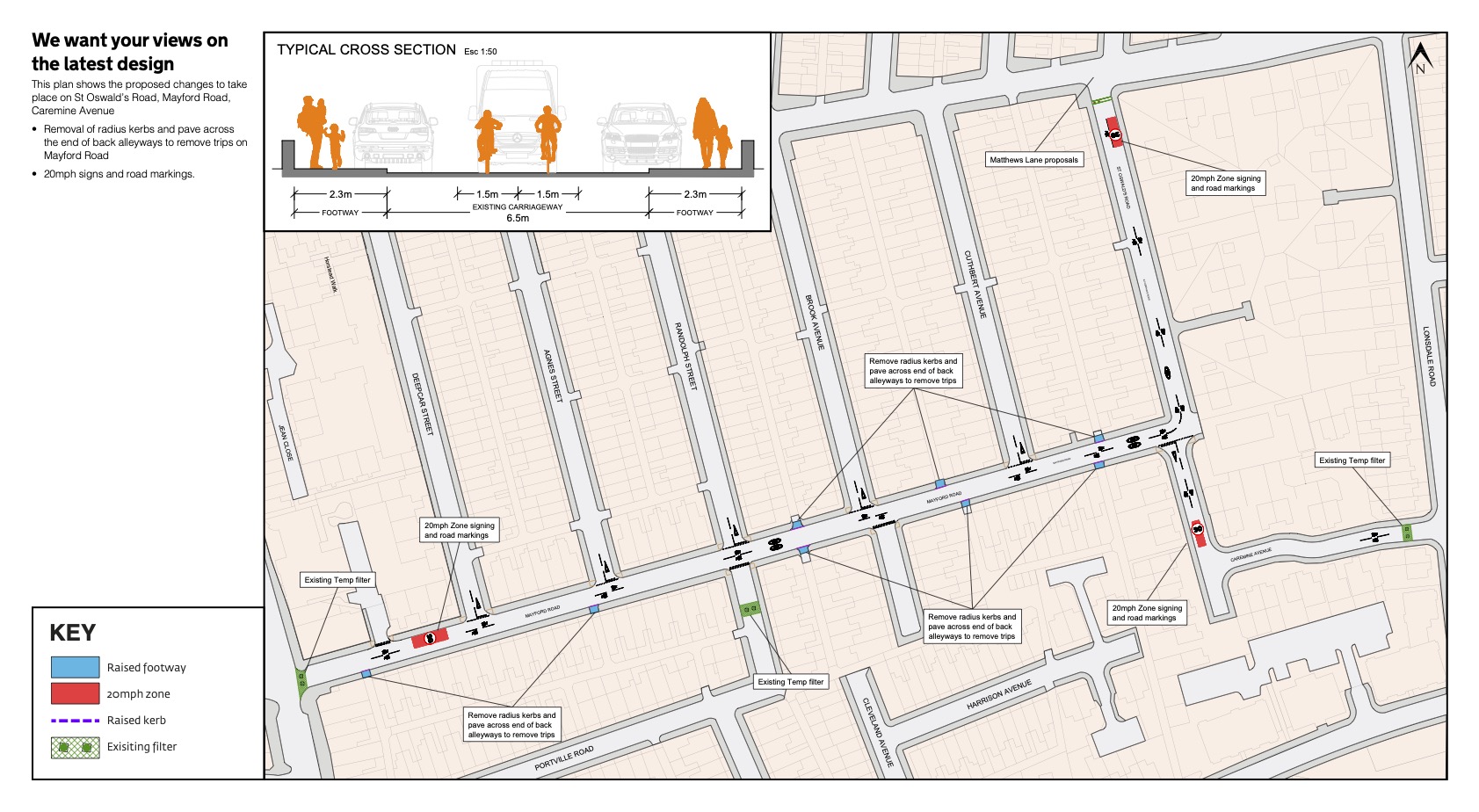
Proposed measures include:
- 20MPH zone sign and road marking as you enter St Oswald’s Road from Matthews Lane in the north, and from Caremine Avenue from the south.
- Radius kerbs removed and entrance to back alleyways paved along Mayford Road to avoid trip hazards.
- 20MPH zone sign and road markings at the south end of Mayford Road. Randolph Avenue and Balleratt Street
- Refresh road markings
- Add 20mph road markings
CHAPEL STREET
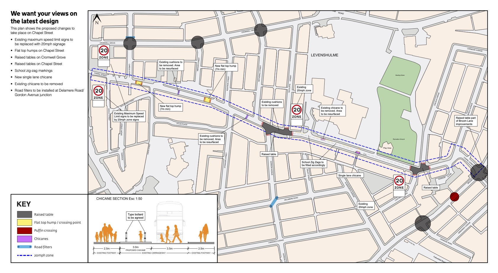
The proposal is to create a new 20mph zone on Chapel Street, and traffic calming measures which link to and complement those on nearby Broom Lane and Cromwell Grove.
Proposed measures include:
- Creating a 20MPH zone along the length of Chapel Street
- Installing 20MPH zone signs and road markings at the western end of Chapel Street, wheretraffic approached from Stockport Road.
- Installing two new flat top humps on Chapel Street east of the junction with Cardus Street and west of the junction with Rostron Street.
- Removing the existing speed cushions near 18 and 38 Chapel Street, and resurface the road at these points.
- Install a raised table and controlled crossing points at the junction of Chapel Street with Gordon Avenue and Ratcliffe Street, and remove speed cushions in this area.
- Remove the existing chicane outside Chapel Street Community Primary School, resurface the area, and create a new 3.0m wide single lane chicane on the south side of Chapel Street.
- Adjust school zigzags between the chicane and the junction with Ratcliffe Street.
- Install a raised table and controlled crossing points at the junction of Chapel Street with Lincoln Avenue and Lostock Avenue.
BROOM LANE

All existing side roads off Broom Lane are currently part of a 20mph zone. This proposed scheme seeks to extend the 20mph zone to include Broom Lane, with a range of traffic calming features and improved crossing facilities.
Proposed measures include:
- 20MPH zone signs and road markings on red surfacing at top and bottom ends of Broom Lane (i.e. junctions with Barlow Road and Stockport Road.
- A 6m long full width, flat top hump south of the junction with Tonbridge Road.
- Footway on west side of Broom Lane to be widened to 1.8m from the junction with Stockport Road to the junction with Cronshaw Street.
- A raised table and controlled crossing points at the junction of Broom Lane with Watts Street.
- Textured paving at all new and upgraded crossings.
- Flat top hump crossing points at the junctions of Bowler Street, Cronshaw Street, Tonbridge Road, Elmsworth Avenue, Marley Road, Thorncliffe Grove, Curtis Road.
- A built out ‘chicane’ on the eastern side of Broom Lane just north of the junction with Tonbridge Road, reducing the carriageway to one lane, with vehicles travelling south giving way to vehicles travelling north.
- A raised table and controlled crossing points at the junction of Watts Street and Broom Lane.
- Upgrading the existing pelican crossing south of the junction of Broom Lane with Broom Avenue to a raised puffin crossing. NB location of new crossing still to be decided – may be slightly further north.
- Construction of a new wall opposite the junction with Crayfield Road to allow the footway to be widened.
- A raised table and controlled crossing point with new pedestrian refuge at the junction of Crayfield Road with Broom Lane.
- A large raised table and controlled crossing points at the junction of Broom Lane with Briston Avenue and Pullman Close.
- A raised table and controlled crossing points at the junction of Broom Lane with Cranage Road.
- Existing ineffective speed cushions south of the junction, located near 135 and 161 Broom Lane to be removed.
- New signal controlled crossing outside 148 Broom Lane
- A large raised table and controlled crossing points at the junction of Broom Lane with Chapel Street and Highfield Road.
- A 6m long full width, flat top hump near 197 Broom Lane.
- A large raised table and controlled crossing points at the junction of Broom Lane with Carnegie Avenue and Dorset Road.
- Existing round top hump on Dorset Road to be removed.
ALMA PARK, ERRWOOD ROAD
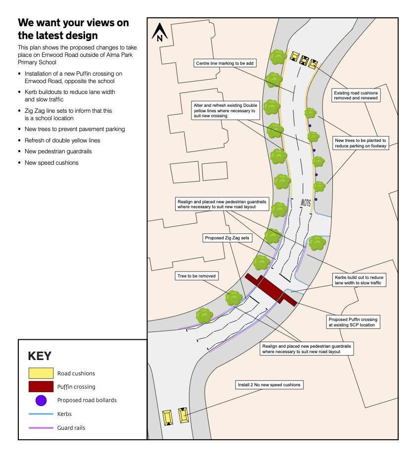
Proposed measures include:
- Existing road cushions on Errwood Road north of Alma Park School to be removed and renewed.
- Centre line markings on Errwood Road to be added
- New trees to be planted to reduce parking on footway
- Bollard to be installed between trees on footway to protect pedestrians and prevent parking
- Add a controlled puffin crossing at the existing school crossing patrol location
- One tree to be removed closest to the new crossing
- Existing double yellow lines to be refreshed and altered where necessary to complement the new crossing
- Building out kerbs to reduce lane width and slow traffic
- Realign pedestrian guard rails and add new ones where necessary on both sides of Errwood Road to suit the new road layout
- Add zig-zag sets (prohibiting parking or overtaking) on both sides of Errwood Road from the double yellow lines down to the junction with Arliss Avenue.
- Install two new speed cushions on Errwood Road south of the junction with Arliss Avenue.
ERRWOOD ROAD
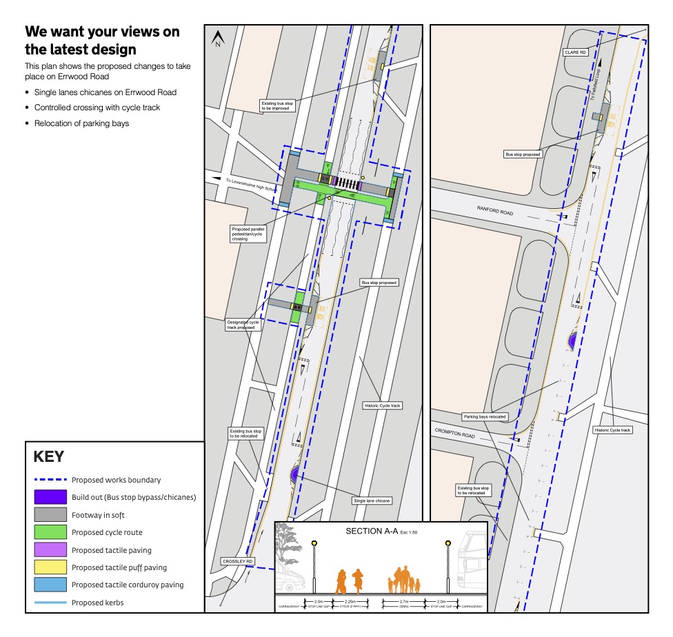
The proposal is to create a 20MPH zone, narrow Errwood Road as it runs alongside Cringle Park, install traffic calming measures and make crossing safer.
Proposed measures include:
- Chicanes on alternate sides of the road which will only allow a single lane of traffic to pass at once.
- Installing a parallel pedestrian and cycle crossing, opposite the side entrance to Levenshulme High school
- Bus stop north of the school side entrance on opposite side from school to be improved
- A new bus stop to the be installed south of the school’s side entrance on the same side as the school
- Exiting bus stop near the junction with Crossley Road to be removed and relocated further south, above the junction with Ranford Road.
- The parking bays on the eastern carriageway of Errwood Road, opposite the junction with Crompton Road, will be relocated.
- A designated cycle track, which links to the Fallowfield Loop
CRAYFIELD ROAD AND MARLEY ROAD
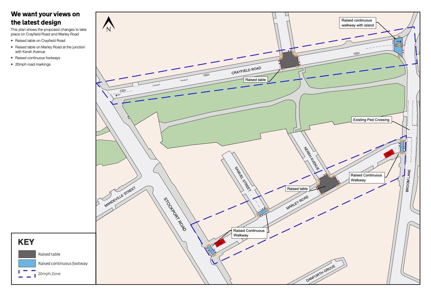
The proposal is to create a 20MPH zone on Crayfield Road and Marley Roads, between Stockport Road in the west and Broom Lane in the east, install traffic calming measures and make crossing easier.
Proposed measures include:
- Double yellow lines added on Crayfield Road near the junction with Stockport Road.
- A raised table and controlled crossing point at the junction of Crayfield Road and Gordon Avenue.
- A raised continuous walkway with a pedestrian island at the junction of Crayfield Road with Broom Lane.
- A raised continuous walkway at the junction of Marley Road with Broom Lane.
- A raised table and three controlled crossing points at the junction of Marley Road with Kersh Avenue
- A raised continuous walkway across Samuel Street at the junction with Marley Road.
- A raised continuous walkway across Marley Road at the junction with Stockport Road.
CROMWELL GROVE
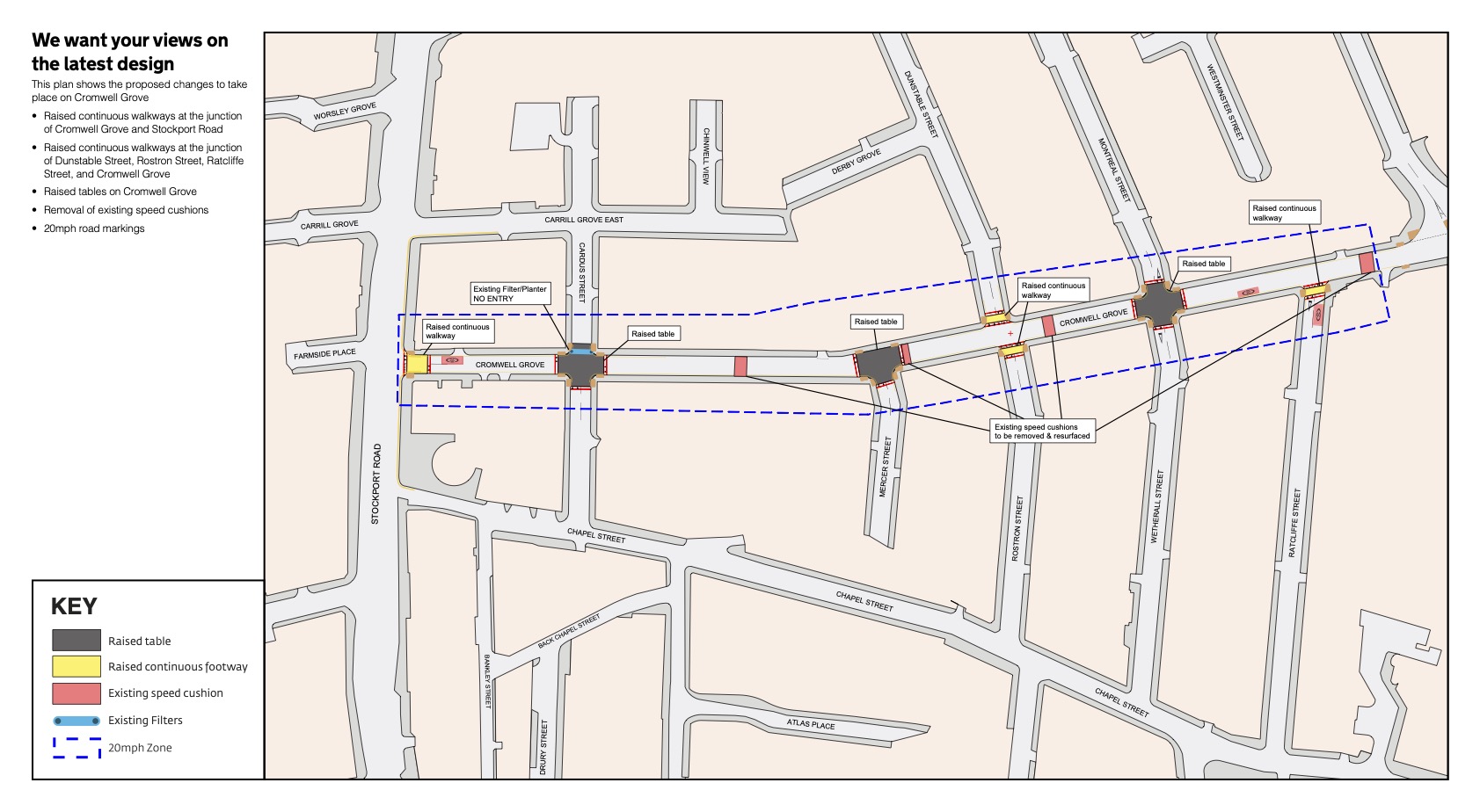
The proposal is to create a 20MPH zone on Cromwell Grove between Stockport Road in the west and Barlow Road in the east, install traffic calming measures and make crossing easier.
Proposed measures include:
- Double yellow lines installed on East side of Stockport Road from Carrill Grove East to Chapel Street.
- Double yellow lines continued along south side of Carrill Road
- Double yellow lines on both sides of Cromwell Road from junction with Stockport Road to beyond the junction with Cardus Street and either side of junctions with Dunstable Street and Montreal Street on north side, and full length on south side.
- A raised continuous walkway across the Stockport Road end of Cromwell Grove.
- A raised table at the junction of Cromwell Grove with Cardus Street, with four way crossing points.
- A raised table at the junction of Cromwell Grove with Mercer Street, with three way crossing points.
- Raised continuous walkway across Dunstable Street and Rostron Street at their junction with Cromwell Grove.
- A raised table at the junction of Cromwell Grove with Montreal Street and Wetherall Street, with four way crossing points.
- Raised continuous walkway across Ratcliffe Street at its junction with Cromwell Grove.
- Textured paving on crossing points at the junction of Cromwell Grove and Barlow Road.
- Existing speed cushions removed and carriageway resurfaced at those points.
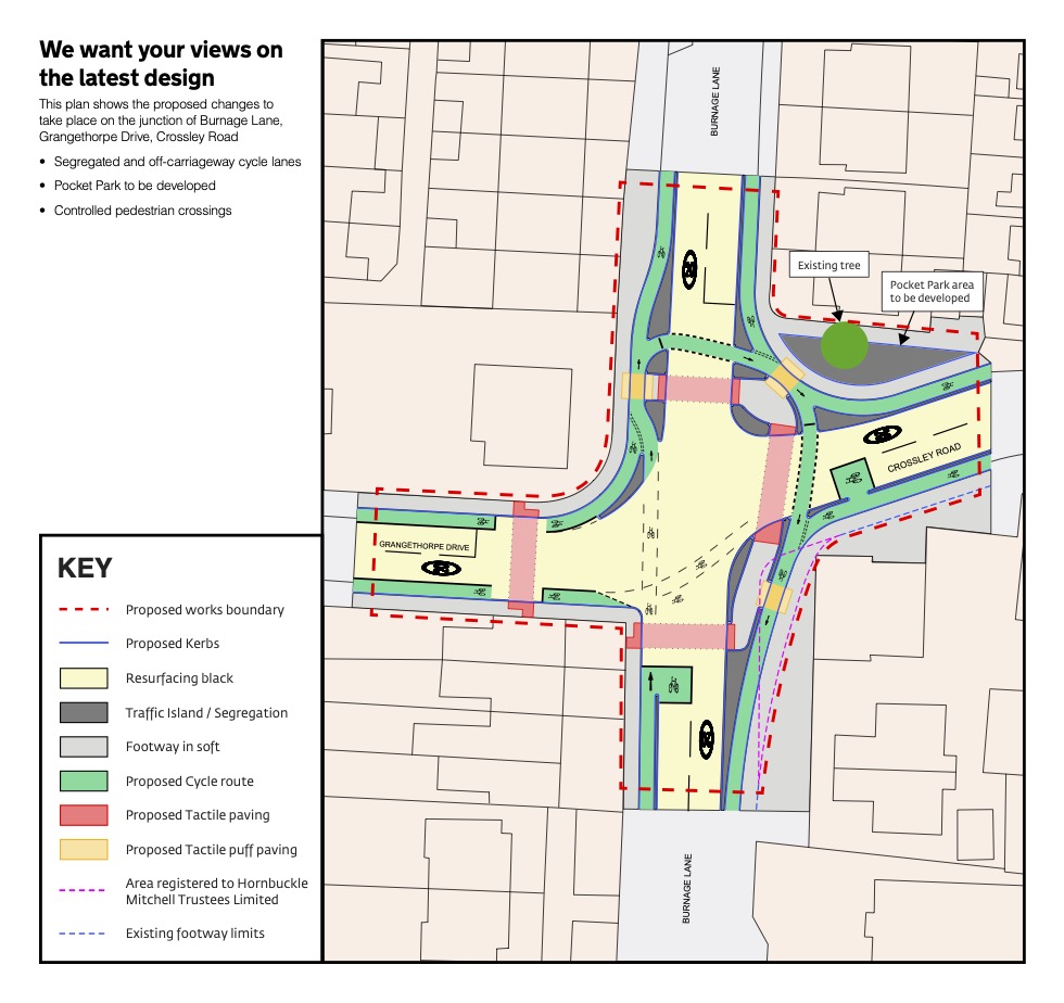
GRANGETHORPE DRIVE
NOTE: This map was only made available on 13 January 2022

The proposal is to create a 20MPH zone on Grangethorpe Drive between Kingsway in the west and Burnage Lane in the east, install traffic calming measures and make crossing easier.
Proposed measures include:
- A raised continuous walkway across the top of Burnside Drive where it meets Grangethorpe Drive.
- A large raised table at the junctions of Grangethorpe Drive, Orville Drive and Hoscar Drive.
- Existing road humps to be removed and carriageway resurfaced at those points.
- A raised continuous walkway across the bottom end of Lynton Drive where it meets Grangethorpe Drive.
- A new flat-top hump (at least 7m long) outside number 19 Grangethorpe Drive.
LINDEN PARK AND MILWAIN ROAD
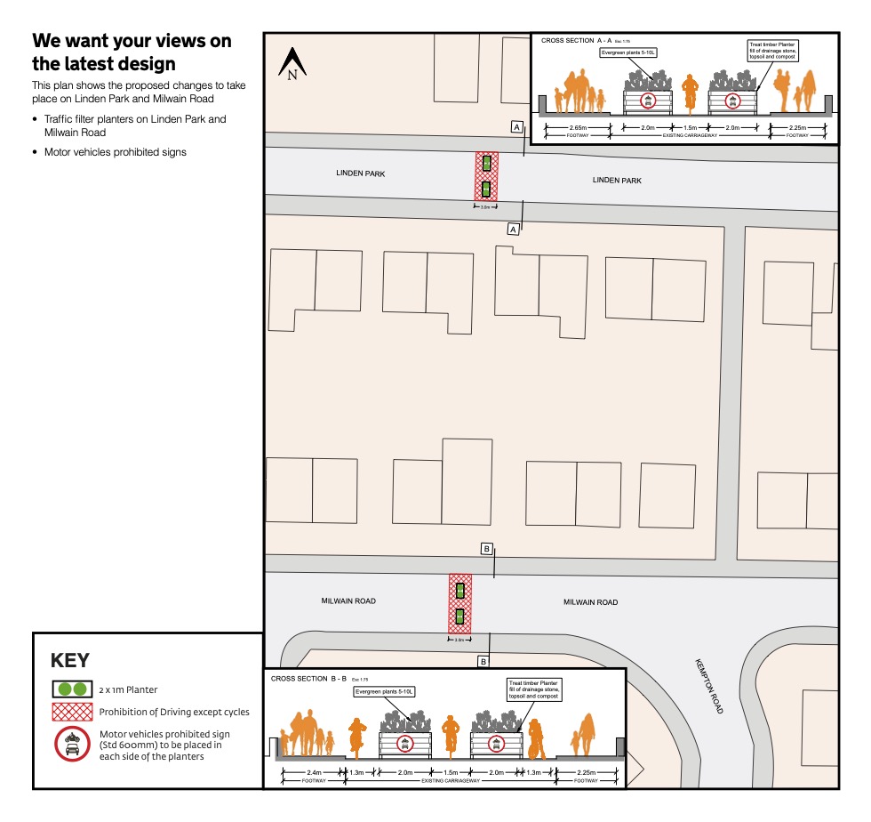
The aim in this area is to prevent vehicles cutting through the area by creating filters on both roads which allow pedestrians and cyclists through but not motor vehicles.
Proposed measures include:
- Installing 2 x 1m timber planters on Linden Park opposite numbers 59 and 61 Linden Park.
- Installing 2 x 1m timber planters on Milwain Road opposite number 62 Milwain Road.
- Planters will feature ‘motor vehicles prohibited’ signs on both sides.
- Advance signage for drivers to stop them turning on to the street.
MOSELEY ROAD / SLADE LANE JUNCTION
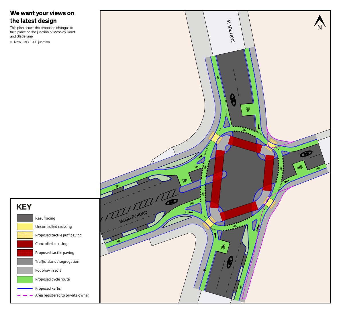
The proposal is to create a ‘cyclops’, (Cycle Optimised Protected Signals) junction where Moseley Road and Slade Lane meet. The design separates pedestrians and cyclists from traffic, reducing the possibility of collisions or conflict. By fully segregating cyclists, it improves safety for all road users.
Proposed measures include:
- Installing cycle lanes, with kerbs to segregate cycles from pedestrians and motor vehicles.
- Creating a continuous path around the junction for cyclists to avoid any need for right turns across the path of oncoming traffic.
- Tactile paving on crossing points.
- Resurfacing road and footways around the junction
- Building out kerbs to make the roads easier to cross at the junction
BURNAGE LANE / GRANGETHORPE DRIVE JUNCTION
The proposal is to create a ‘cyclops’, (Cycle Optimised Protected Signals) junction where Burnage Lane and Grangethorpe Drive meet. The design separates pedestrians and cyclists from traffic, reducing the possibility of collisions or conflict. By fully segregating cyclists, it improves safety for all road users.
Proposed measures include:
- Installing cycle lanes, with kerbs to segregate cycles from pedestrians and motor vehicles.
- Creating a continuous path around the junction for cyclists to avoid any need for right turns across the path of oncoming traffic.
- Tactile paving on crossing points.
- Resurfacing road and footways around the junction
- Building out kerbs to make the roads easier to cross at the junction
MANOR ROAD EAST
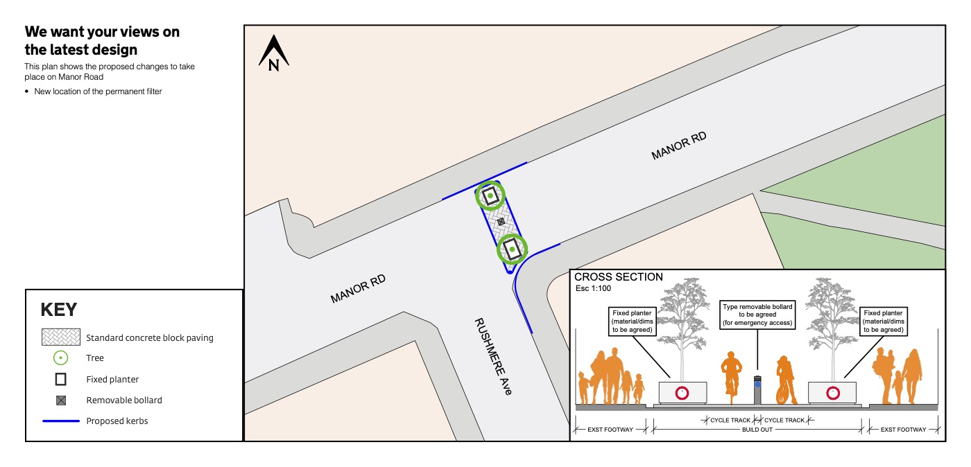
A new location for the traffic filter is proposed.
RANDOLPH STREET / BALLERATT STREET
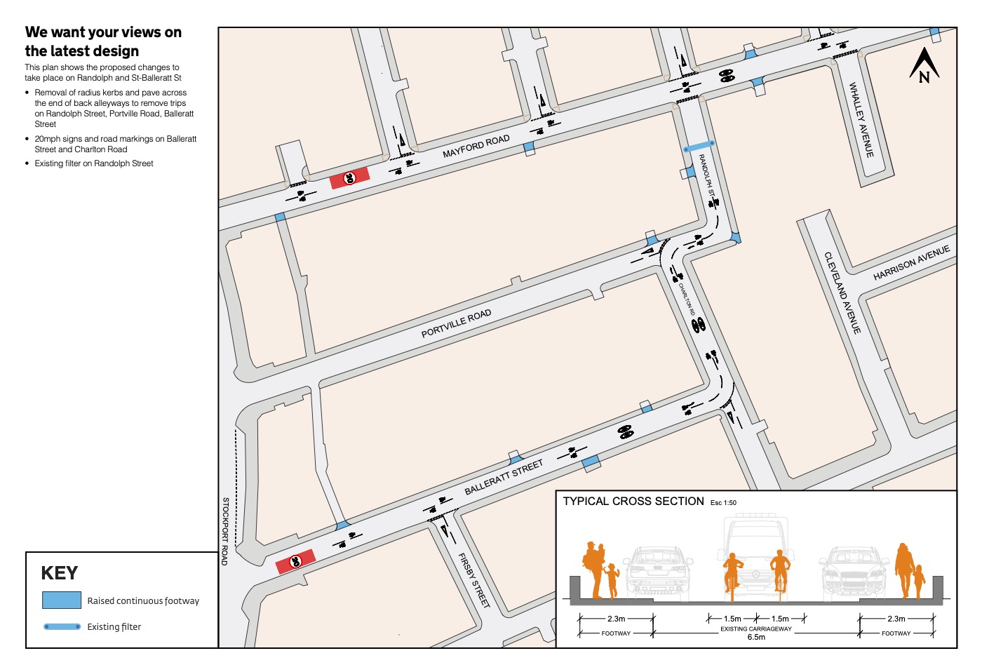
NOTE: No description of any of these measures has been published for this location yet (2 January 2022)