Levenshulme Community Association and Levenshulme Traders Association have jointly called for the current Active Neighbourhood consultation to be extended. There are multiple problems with the way the consultation is being run. We believe these problems must be corrected and then the consultation should be extended to allow proper community engagement.
The letter and concerns are reproduced below and have been sent on 11 January 2022 to: Levenshulme councillors (Zahid Hussain, Dzidra Noor and Basat Sheikh); Burnage councillors (Azra Ali, Ben Clay and Bev Craig who is also Manchester City Council Leader); Manchester City Council Executive member Tracey Rawlins; Andy Burnham (Greater Manchester Mayor); and local MPs Afzal Khan and Jeff Smith. Copied to the Levenshulme and Burnage Active Neighbourhood Project Team.
The project has now been split into two with Phase 1 covering Levenshulme and Phase 2 covering Burnage. A trial of road blocks / “modal filters” will start in December 2020 and last for a minimum of six months.
Note that a “modal filter” is the name given to something that blocks the road to vehicular traffic but still allows access through for pedestrians and cyclists (and presumably mopeds and motorbikes).
Manchester City Council says:
We now have a plan for the future direction of the project, and have decided to tackle it in two phases. We would like your feedback on some of the measures which we are going to trial (Phase 1). The trial measures will start to be put in place from December (during school holidays).This is also a great way for the scheme to be seen in action, tested and analysed, so it can be tweaked or changed where required but also allow peoples habits to change and through traffic to re-route.
Because of the density of schools in the Cringle Park (Phase 2) area, and issues with traffic congestion, we are continuing to seek opinions from local residents, businesses and schools on what measures are needed and where before they are trialled.
We hope to commence the trial in the Festive season break in December and will last a minimum of 6 months. The final designs for the Active neighbourhood will be drawn up based on the results of the consultation and implemented within 18 months should the funding application be successful.
MCC Active Neighbourhood Plans
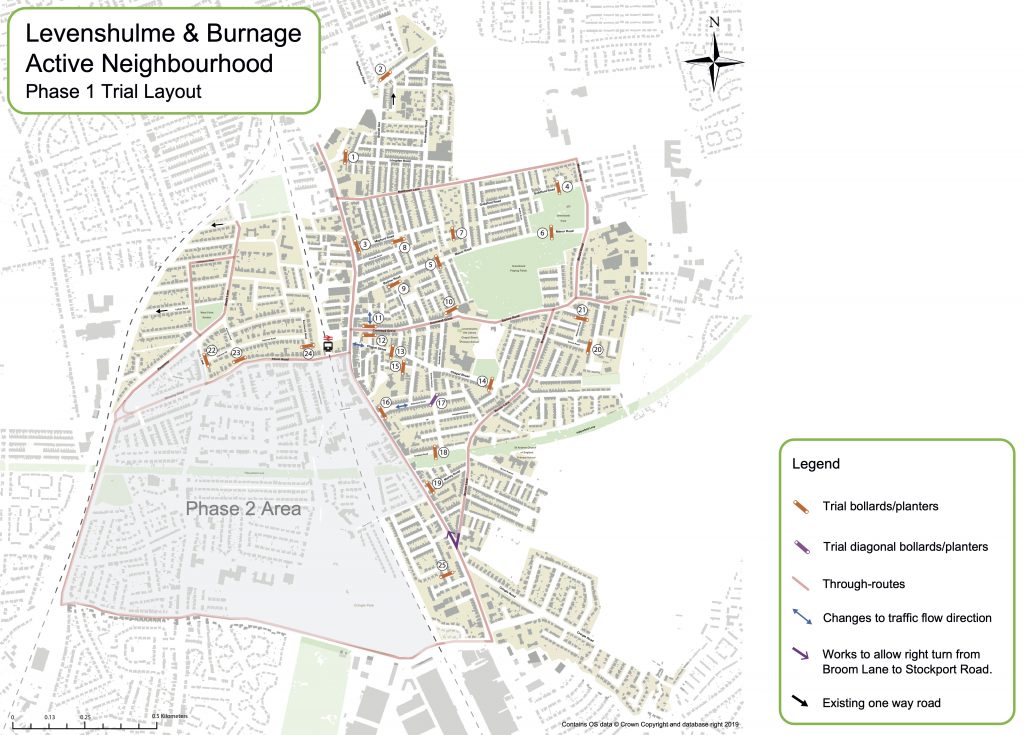
The Phase 1 trial area excludes Burnage. No date has been suggested yet for Phase 2 in Burnage. The Phase 1 / Phase 2 split has been done based on political Wards, not the Park Area cells the Project has identified which is why the Henderson Street road block / “modal filter” is included in Phase 1.
The Levenshulme Phase 1 trial identifies 25 road blocks / “modal filters” outlined on the map below. The revised plans are not very different to the original plans. We will look at them in detail and post further information once we have worked out what differences there are.
The Phase 1 trial is still primarily for road blocks / “modal filters”. The council is also asking for feedback on where temporary crossings and traffic calming could be located as part of its Phase 1 consultation. The council says:
The trial includes a number of temporary crossing points and traffic calming measures to provide immediate benefits on routes that have been raised through previous consultation. [ * ]
We understand from previous feedback that traffic volume and speeds make certain streets hard to cross. We’d like you to tell us where you feel crossing points or traffic calming may help day to day life and make getting around safer and easier.
Further community feedback on the locations of these is welcomed, so that a final Trial Plan can be developed. The trial plan has a degree of flexibility once live, but we need to allow the trial to bed in to understand how habits change and the trial is being used.
MCC Active Neighbourhood crossings and traffic calming
[ * NOTE: there is no evidence of this on the map for the Phase 1 trial]
Give your feedback
Phase 1 feedback (Levenshulme) can only be made by responding to the 25 locations identified by the council. You can, however, drop a pin on the map for the Phase 2 feedback (Burnage) to identify a location and comment where you think an intervention could or should be located.
Phase 1 (Levenshulme)
You can comment HERE on the proposed road blocks / “modal filters”.
You can comment HERE on where you think crossings and traffic calming should go.
Car Free Day encourages motorists to give up their cars for a day. Organised events are sometimes held but the general aim is to encourage walking and cycling and use of public transport instead of cars.
The European Union has since 2001 extended this idea to European Mobility Week culminating in the World Car Free Day. The UK has two cities participating (London and Nottingham) compared to 540 locations in Turkey, 534 in Austria and 530 in Spain.
Manchester City Council is currently developing plans for an Active Neighbourhood in Levenshulme and Burnage to encourage and make walking and cycling easier. The project was paused in the summer but revised plans and letters with information to residents and businesses are expected soon.
The first proposal of the Levenshulme and Burnage Active Neighbourhood is to trial a “Low Traffic Neighbourhood (LTN)” in the form of multiple road blocks to vehicles (referred to as “modal filters”). These would restrict routes for vehicles whilst allowing pedestrians and cyclists free access. 32 filters were initially proposed in May 2020 but the revised plans are likely to change from that. Keep an eye out for the letters and information.
Levenshulme Community Association is grateful to Manchester Urban Observatory for this article following contact with Dr Jen O’Brien and Prof. James Evans. We will continue to provide information and updates as they become available to help everyone understand the Active Neighbourhood proposals and be involved in the process to get the best we can for our community. This fits with several of the aims of the Levenshulme Community Manifesto.
Manchester Urban Observatory and the Levenshulme Active Neighbourhood – improving decision making with data
The Manchester Urban Observatory is part of a network of 6 Urban Observatories across England which are developing a new approach to the monitoring and understanding of cities. Our goal is to ensure future decision making is informed by a detailed appreciation of the consequences and complexity of urbanisation. The Manchester Urban Observatory is based at the University of Manchester, bringing together expertise from across the humanities, environmental sciences and health. Our role is to work with local partners to support the better planning and delivery of urban development. We operate entirely independent, with our funding secured through the UK Collaboratorium on Infrastructure and Cities.
Manchester City Council has confirmed a new opportunity for residents to organise Play Streets. The council says:
“We want more of our residents from all parts of the city to come together to close the road or street where they live to help children’s play. A group of residents can apply to close their road on a regular basis for a few hours each time so there is no danger or inconvenience from through traffic.”
Full details are available HERE including information on:
suitable streets
when to hold a play street session
getting support from neighbours
managing traffic
volunteers and marshalls
fees and how to apply for permission
getting support from your local Neighbourhood Team
Play Streets were trialled in Levenshulme in 2019 as part of the Levenshulme Active Neighbourhood Project via the Levenshulme Bee Network group. Six streets ran Play Street trials including Osborne Road and Central Avenue. There was a report on the Osborne Road trial in the Manchester Evening News which can be read HERE.
Although Levenshulme Bee Network is no longer part of the Active Neighbourhood Project that project continues and you can organise Play Streets by following the council guidance. The idea for Play Streets was borrowed from the Playing Out community project that started in Bristol in 2011. You can find out about them HERE and get ideas for how to make Play Streets work.