
The revised plans for the Levenshulme and Burnage Active Neighbourhood have been released. Full information is available on the new website HERE.
The project has now been split into two with Phase 1 covering Levenshulme and Phase 2 covering Burnage. A trial of road blocks / “modal filters” will start in December 2020 and last for a minimum of six months.
Note that a “modal filter” is the name given to something that blocks the road to vehicular traffic but still allows access through for pedestrians and cyclists (and presumably mopeds and motorbikes).
Manchester City Council says:
We now have a plan for the future direction of the project, and have decided to tackle it in two phases. We would like your feedback on some of the measures which we are going to trial (Phase 1). The trial measures will start to be put in place from December (during school holidays).This is also a great way for the scheme to be seen in action, tested and analysed, so it can be tweaked or changed where required but also allow peoples habits to change and through traffic to re-route.
Because of the density of schools in the Cringle Park (Phase 2) area, and issues with traffic congestion, we are continuing to seek opinions from local residents, businesses and schools on what measures are needed and where before they are trialled.
We hope to commence the trial in the Festive season break in December and will last a minimum of 6 months. The final designs for the Active neighbourhood will be drawn up based on the results of the consultation and implemented within 18 months should the funding application be successful.
MCC Active Neighbourhood Plans
The Phase 1 trial area excludes Burnage. No date has been suggested yet for Phase 2 in Burnage. The Phase 1 / Phase 2 split has been done based on political Wards, not the Park Area cells the Project has identified which is why the Henderson Street road block / “modal filter” is included in Phase 1.
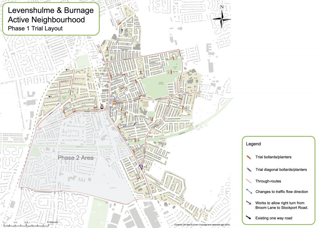
The Levenshulme Phase 1 trial identifies 25 road blocks / “modal filters” outlined on the map below. The revised plans are not very different to the original plans. We will look at them in detail and post further information once we have worked out what differences there are.
The Phase 1 trial is still primarily for road blocks / “modal filters”. The council is also asking for feedback on where temporary crossings and traffic calming could be located as part of its Phase 1 consultation. The council says:
The trial includes a number of temporary crossing points and traffic calming measures to provide immediate benefits on routes that have been raised through previous consultation. [ * ]
We understand from previous feedback that traffic volume and speeds make certain streets hard to cross. We’d like you to tell us where you feel crossing points or traffic calming may help day to day life and make getting around safer and easier.
Further community feedback on the locations of these is welcomed, so that a final Trial Plan can be developed. The trial plan has a degree of flexibility once live, but we need to allow the trial to bed in to understand how habits change and the trial is being used.
MCC Active Neighbourhood crossings and traffic calming
[ * NOTE: there is no evidence of this on the map for the Phase 1 trial]
Give your feedback
Phase 1 feedback (Levenshulme) can only be made by responding to the 25 locations identified by the council. You can, however, drop a pin on the map for the Phase 2 feedback (Burnage) to identify a location and comment where you think an intervention could or should be located.
Phase 1 (Levenshulme)
You can comment HERE on the proposed road blocks / “modal filters”.
You can comment HERE on where you think crossings and traffic calming should go.
You can comment HERE on the whole scheme.
Phase 2 (Burnage)
You can comment HERE on what measures you think should be included in Phase 2.
How has the Project Changed?
There are a number of differences between the May proposals and the new proposals released in September. A summary is provided here for reference.
Levenshulme and Burnage Active Neighbourhood Project v1 and v2 Comparison
( RB/MF = Road Block / “Modal Filter” )
| Version 1May 2020 | Version 2 Sept 2020 | v2 Map ref. | Changes | |
| Green Bank Park Area | ||||
| Longden Road | RB/MF | RB/MF | 1 | Same as v1 |
| Armitage Avenue | RB/MF | RB/MF | 2 | Same as v1 |
| Mayford Road | RB/MF | RB/MF | 3 | Same as v1 |
| Guildford Road / Audley Road | RB/MF (Diagonal) | RB/MF | 4 | Moved along Guildford Road and now a standard RB/MF |
| Stovell Avenue / Northmoor Road | Bus Gate | Bus Gate removed | ||
| Manor Road 1 (between Barlow Road and Rushmere Avenue) | RB/MF | RB/MF | 5 | Same as v1 |
| Manor Road 2 | RB/MF | 6 | Moved to where a new crossing was proposed originally | |
| Caremine Avenue | RB/MF | 7 | EXTRA RB/MF | |
| Portville Road | RB/MF | RB/MF | 8 | Same as v1 |
| Dunstable Street | RB/MF | RB/MF | 9 | Same as v1 |
| Barlow Road | RB/MF | RB/MF | 10 | Same as v1 |
| Cardus Street (North) | RB/MF | 11 | EXTRA RB/MF and road changed to two-way traffic | |
| Chapel Street Park Area | ||||
| Cardus Street (South) | RB/MF | 12 | Same as v1 | |
| Chapel Street (West) | RB/MF | RB/MF | 13 | Same as v1 |
| Chapel Street (East) | RB/MF | RB/MF | 14 | Same as v1 |
| Chapel Street / Stockport Road junction | Changed to two-way traffic | |||
| Atlas Place | RB/MF | RB/MF | 15 | Same as v1 |
| Delamere Road (West) | RB/MF | RB/MF | 16 | Same as v1 with road changed from one-way to two-way traffic |
| Delamere Road / Gordon Avenue | RB/MF (Diagonal) | RB/MF | 17 | Same as v1 |
| Crayfield Road | RB/MF | RB/MF | 18 | Same as v1 |
| Marley Road | RB/MF | RB/MF | 19 | Same as v1 |
| Dorset Road | RB/MF | RB/MF | 20 | Same as v1 |
| Molyneux Road | RB/MF | RB/MF | 21 | Same as v1 |
| Broom Lane / Stockport Road junction | Changed to allow left and right turning | |||
| Cromwell Grove / Stockport Road junction | Changed to allow left and right turning | |||
| West Point Gardens Area | ||||
| Osborne Road | RB/MF | RB/MF | 22 | Same as v1 |
| Victoria Road | RB/MF (Diagonal) | RB/MF | 23 | Changed from diagonal RB/MF to standard and moved to junction with Albert Road |
| Buckhurst Road | RB/MF | RB/MF | 24 | Same as v1 |
| Green Drive | RB/MF | RB/MF removed (private road) | ||
| Lytham Road | RB/MF | RB/MF removed and road left as it is now | ||
| Cringle Park Area (Burnage) | ||||
| Fortuna Grove / Monica Grove | RB/MF (Diagonal) | Further consultation | ||
| Burnage Hall Road | RB/MF | Further consultation | ||
| Slade Lane (near Linden Park) | Bus Gate | Further consultation | ||
| Errwood Road (near Alma Park Primary) | Bus Gate | Further consultation | ||
| Clare Road | RB/MF | Further consultation | ||
| Alma Road | RB/MF | Further consultation | ||
| Henderson Street | RB/MF | RB/MF | 25 | Same as v1 |
Levenshulme & Burnage Active Neighbourhood Phase 1 Map
You can view the map online HERE or download a PDF version below.
Pingback: Active Neighbourhood Dates | Levenshulme Community Association