
Levenshulme and surrounding areas are about to experience major changes to our roads.
This is the first stage of the changes being imposed by the Levenshulme Bee Network Project. This is a new idea to create a “Filtered Neighbourhood” and to make walking and cycling easier by blocking off roads and restricting access for motorised vehicles. A whole host of other ideas are planned as well. This is just the start.
Travelling around Levenshulme and getting to and from the area will never be the same again.
12 June update
Please note that the information below was correct when it was posted. However, Levenshulme Bee Network has now changed the description on its website about the July 2020 changes. There is nothing on their website to indicate this has been changed.
Original text when the announcement was made:
“In the next few weeks we will be installing 29 temporary modal filters throughout the neighbourhood.
These will remain in place for a minimum of six months whilst we consult and tweak the filters with your feedback. They will then become permanent within 18 months.”
New text as of 12 June 2020:
“In the next few weeks we will be installing 29 temporary modal filters throughout the neighbourhood.
The trial will be undertaken using an experimental traffic regulation order which means that we can make changes following your feedback and monitor the impact for the first 6 months before the Council decides if the filters will be implemented on a permanent basis. All feedback from residents and monitoring of traffic, pedestrian and cycling levels as well as air quality levels will be considered before any of the filters are installed permanently.”
See below for details of the roads that will be affected, what will be done in July and maps including these changes.
Summary of Levenshulme Bee Network Road Changes from July 2020
- Multiple changes are planned starting in July 2020 using temporary physical barriers at 29 locations.
- The road blocks / “modal filters” will restrict access for motorised vehicles.
- Roads will still be accessible to pedestrians and cyclists.
- Residents and businesses have not been consulted in advance about these specific proposals although Levenshulme Bee Network has undertaken a series of events and activities over the last year to promote its ideas and help people understand the concepts being proposed.
- A six month consultation will start after these changes have been made in July 2020.
- The consultation may allow some “tweaks” to the design of the road blocks before they are replaced with permanent versions but they will not be moved from these locations.
- After the consultation the temporary road blocks will be made permanent.
How will roads be blocked?
There are three ways roads will be blocked to motorised traffic in this stage the project:
Simple Filter: planters, bollards, simple pavement build-outs, trees, bike parking, signage
Fancy Filter: planters, bollards, simple pavement build-outs, trees, bike parking, signage, seating, plants, sculpture, artwork, play or exercise equipment
Diagonal Filter: diagonal placement of “things” at junctions to force traffic to divert in one direction only onto another road
Please note the changes you will see in July 2020 will be temporary versions of these “filters” before they are made permanent after the consultation period ends.
Roads affected from July 2020
- The Levenshulme Bee Network extends across Levenshulme and includes parts of Burnage and Rusholme Wards
- Four “Park Areas” have been identified by the Bee Network.
- Maps of the areas are below for reference.
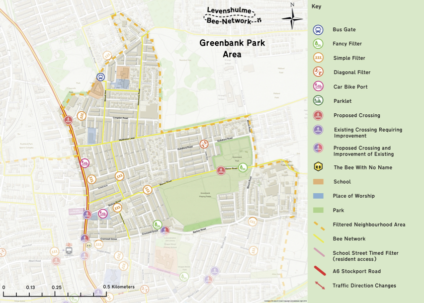
| Greenbank Park Area | |
| Location | How will the road be blocked? |
| Audley Road / Guilford Road | Diagonal Filter with no travel north-south in either direction |
| Armitage Avenue | Simple Filter |
| Longden Road (near Hannah Street) | Simple Filter |
| Mayford Road (near Stockport Road) | Simple Filter |
| Portville Road (near Randolph Street) | Simple Filter |
| Manor Road (near Rushmere Avenue) | Simple Filter |
| Manor Road (near Greenbank Park) | Fancy Filter |
| Chapel Street Park Area | |
| Location | How will the road be blocked? |
| Dunstable Street | Simple Filter |
| Chapel Street (near Rostron Street / Mercer Street) | Simple Filter |
| Chapel Street (near Chapel Street Primary School) | Fancy Filter |
| Cardus Street | Simple Filter |
| Crayfield Road | Simple Filter |
| Atlas Place (near Stanhope Street) | Simple Filter |
| Gordon Avenue / Delamere Road | Diagonal Filter with no travel east-west in either direction |
| Barlow Road / Cromwell Grove | Fancy Filter |
| Delamere Road | Simple Filter |
| Dorset Road | Simple Filter |
| Molnyeux Road (nearest Barlow Road) | Simple Filter |
| Marley Street (near Stockport Road) | Simple Filter |
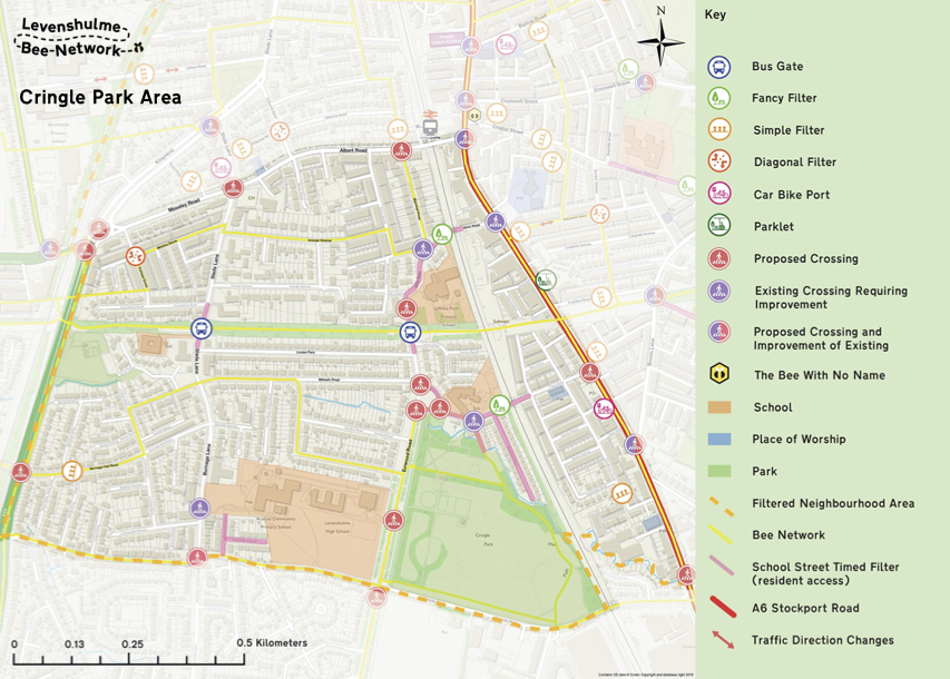
| Cringle Park Area | |
| Location | How will the road be blocked? |
| Fortuna Grove / Monica Grove | Diagonal Filter with no travel east-west in either direction |
| Burnage Hall Road (near Orville Drive) | Simple Filter |
| Clare Road (near railway bridge) | Fancy Filter |
| Alma Road (near Marshall Road) | Fancy Filter |
| Henderson Street | Simple Filter |
| West Point Gardens Area | |
| Location | How will the road be blocked? |
| Buckhurst Road | Simple Filter |
| Victoria Road / Osborne Road | Diagonal Filter with no travel north-south in either direction |
| Osborne Road (near Slade Lane) | Simple Filter |
| Green Drive | Simple Filter |
| Lytham Road (near railway bridge) | Simple Filter |
Levenshulme Bee Network is a joint initiative between Transport for Greater Manchester, Manchester City Council and Sustrans with advice from Bespoke Transport Consulting. Local resident Pauline Johnston has been employed as Project Coordinator. A group of Levenshulme Bee Network Advocates has been created to promote the project, provide input from local residents and undertake street surveys.
Future stages of the project will involve other changes including restricting access by installing Bus Gates around the area and creating school zones inaccessible to traffic at school pick up and drop off times. Other elements will be putting in bike racks, bike hangers on residential streets and a new bike hub on the Levenshulme Station car park. There are also plans to reduce / remove clutter on the streets and install new crossings. No traffic calming measures, one way streets or cycle lanes are currently planned as part of the project.
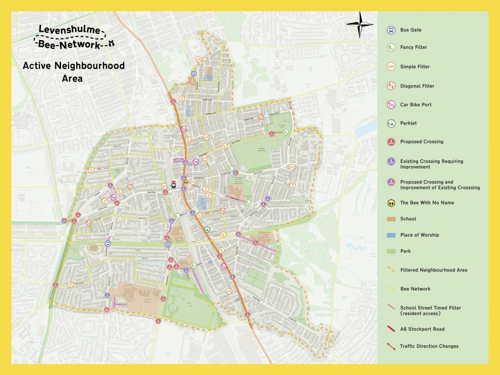
The Levenshulme Bee Network Active Neighbourhood Vision Map is also provided below for reference. This includes more, although not all, of the proposed changes.
Further information is available on the Levenshulme Bee Network Project website HERE
PDF versions of the maps can be downloaded here:

I can’t see how I can get to work in Manchester other than going to Hyde Road or via Burnage. Both these routes take me in the wrong direction and embroiled in traffic. More congestion and more pollution. I live off broom lane. I am mobility impaired so driving is my only option. It’s hard enough to work full time and manage medical conditions and activities of daily living. It’s going to at least double my travelling time probably much much more. That will reduce my leisure time to a few hours a week at the weekend. How can a scheme like this be justified? I raised my concerns when it was first mooted. Obviously people like me just don’t matter. You have no idea what a negative impact this is going to have on my quality of life. And clearly don’t care!
i totally agree with you not thought out at all will cause massive distruotion on the a6 and not took into account people with disabilitys totel waste of time and money to distrupt peoples lives people use cars for work aswell just be stuck in traffic even more so on a6 with no way out
I can’t see how I get home to a dead end Grove without a major redirection creating even more traffic on Stockport Road. Thanks for the massive inconvenience making my 12 hour working day into a 13 hour one.
So a group of unelected people have decided they will choose where I go and how I do it. What kind of Fascist State are we in now. What the Hell so you mean when you say it will be ‘imposed’ and made permanent? Who gave you the power to do that and how do we challenge it? Because if I can’t then I’ve got a list of my own things I’m going to impose on Levenshulme.
Thanks for your comments. For clarification Levenshulme Community Association shared this information to keep people informed when we became aware of these proposals.
Levenshulme Bee Network is responsible for this project with its own partners.
Levenshulme Community Association is not a partner in the Levenshulme Bee Network project.
We have invited Levenshulme Bee Network representatives to our public general meetings to explain this project but unfortunately nobody has been available to attend. LCA Officers have also attended various Levenshulme Bee Network events to positively engage with the project.
The LCA has been supportive of the ideas proposed by the Levenshulme Bee Network regarding making our streets safer and improving walking and cycling in the area. We have discussed this at our public meetings and agreed this.
This is a fantastic opportunity for Levenshulme with major investment in the area. We want to help make it a success for everyone – residents, businesses and visitors – but we are not responsible for how the Levenshulme Bee Network is managed.
Jeremy Hoad
LCA Secretary
This all sounds great for the minority of residents who cycle in the area and also will not impact those who are fit enough to walk. Unfortunately as an elderly resident with health problems I can do neither. I agree that there are traffic problems in the area that need addressing but not by blocking off roads leading to more congestion and more air pollution. What really needs to happen is to reduce the amount of traffic and there is an easy solution to this problem. I have lived in the Levenshulme /Burnage area for over three quarters of a century and one of the best features of the area is it’s accessibility to all areas being centrally situated between Manchester and Stockport, which makes it a desirable place to live. The main problem is caused by parents dropping children off at school. My understanding is that primary school children attend schools within their own catchment area, so why the need for a half mile car journey? There is no point parents complaining about their child’s safety and air quality when they are the route cause of it. Parents should be penalised for driving their children to school unless they have an exceptional need to do so. In the case of secondary school children they are old enough to use public transport or school buses. It feels, and sounds, like residents are going to be adversely affected by these measures because a large proportion of parents and secondary school children are too lazy to walk to school or take public transport which, in effect, is what people such as myself are going to be forced to do. I also wonder what these measures will do to house prices in the area as it quickly becomes a ‘no go’ area.
Pingback: Videochats About Road Changes | Levenshulme Community Association
I was never inform of any of these changes and I live near to Manor rd which looks like it is going to be closed both ways, Can these people really do this without consulting residents that will be affected ? I am finding hard to get in touch with anyone who can help or who I can log objections too. I agree we have problems near where I live but the way this has been done is wrong.
Pingback: Levenshulme Bee Network Through Routes | Levenshulme Community Association
no regard for people that live and work here